Route Editor

| Guide | 0 Triplogs | 0 Topics |
details | drive | permit | forecast | route |
stats |
photos | triplogs | topics | location |
| 21 | 0 | 0 |
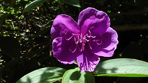
Great Flora by slegal At about eight-tenths of a mile in, you will want to head off to the right on Mohihi Road, another dirt road with vehicle traffic. Mohihi Road heads straight to the Berry Flats Trail. There is a trailhead marker on the left side of Mohihi Road. If you have a handheld GPS, the trailhead is at N22? 07.848 W159? 38.327.
Once on the Water Tank there is one substantial difference that you'll notice compared to the Berry Flat Trail. You will start seeing an abundance of a plant with a flower that looks like a yellow lantern. This plant is called Kahili Ginger. This is an invasive weed and the state of Hawaii is fighting a losing battle to eradicate it. Interestingly, until recently, Hawaiians loved this flower because of how fragrant it is. It was used in ornamental gardens. As the trail continues on you'll pass a number of trees that have some very unusual root structures. When I say unusual I mean above ground unusual. In fact, one of these trees straddles the trail forcing you to walk under the roots. I'm 6' 3" tall and I didn't even have to duck to walk under these roots. Eventually, the Water Tank Trail will end at a dirt road that will take you straight to Highway 550. From here you will have to walk southwest down highway 550 until you get back to the State Park Headquarters. Note that Highway 550 is pretty busy and is narrow without much of a shoulder. So be careful. Check out the Official Route. Leave No Trace and +Add a Triplog after your hike to support this local community. | |||||||||||||||||||||||||||||||||||||||||||||||||||||||||||||||||||||||||||||||||||