Overview: A challenging part of the Apacheland/Heiroglyphic trail system. This singletrack was designed by and for mountain bikers but is also friendly to horses and hikers.
When hiking several trails on a single "hike", log it with a generic name that describes the hike. Then link the trails traveled, check out the example.
WARNING! Hiking and outdoor related sports can be dangerous. Be responsible and prepare for the trip. Study the area you are entering and plan accordingly. Dress for the current and unexpected weather changes. Take plenty of water. Never go alone. Make an itinerary with your plan(s), route(s), destination(s) and expected return time. Give your itinerary to trusted family and/or friends.
Permit $$
AZ State Recreational Land Permits
For hiking, driving & sightseeing purposes, you seek a recreational permit.
Under "Recreational Land Use" in the link above.
2022 - $15.00 individual
2022 - $20.00 family limited to two adults and children under the age of 18
Plus $1 processing fee
The permitting process is quick, you will be emailed your permit instantly.
To hike Kings Ranch Road, 2 miles north of Highway 60. Parking is near the driveway for the long gone Apacheland movie set. Follow the dirt road back to a gate at the state land boundary. Take the Cougar Trail to the Vortex Trail to Gila Monster. Heiroglyphic Trailhead is an option, see GPS under Cougar Trail.
 Route Editor

 Overview: A challenging part of the Apacheland/Heiroglyphic trail system. This singletrack was designed by and for mountain bikers but is also friendly to horses and hikers.
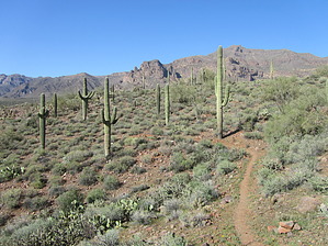


