Route Editor

| Guide | ♦ | 15 Triplogs | 0 Topics |
details | drive | no permit | forecast | 🔥 route |
stats |
photos | triplogs | topics | location |
| 86 | 15 | 0 |
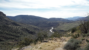
Rocks, Rocks and more Rocks! by topohiker  For one thing, never believe the forest service write-ups. The FS write-up claimed that the Twin Buttes TH was 7 miles to the Verde River. We had parked about a 1/2 mile from the actual TH. We drove to what I had thought was the end of FR 194. There's a sign pointing the way to the Verde River trail #11. We parked here in a nice big turn-off. The first 1/2 mile of the hike was on a nice jeep road that would be OK for high clearance or 4 x 4 vehicles (I wouldn't take a small SUV on this road, there were some minor steps to contend with). After a 1/2 mile, we came to the true TH. There was a pickup truck parked here. For one thing, never believe the forest service write-ups. The FS write-up claimed that the Twin Buttes TH was 7 miles to the Verde River. We had parked about a 1/2 mile from the actual TH. We drove to what I had thought was the end of FR 194. There's a sign pointing the way to the Verde River trail #11. We parked here in a nice big turn-off. The first 1/2 mile of the hike was on a nice jeep road that would be OK for high clearance or 4 x 4 vehicles (I wouldn't take a small SUV on this road, there were some minor steps to contend with). After a 1/2 mile, we came to the true TH. There was a pickup truck parked here.The TH is at 5,800 feet, and the trail descends to the river from here. We had expected a 14 ~ 15 mile round trip hike. The day was already warm as we started hiking. The trail follows a very old jeep road that had some washed-out parts and is very rocky. Even though it's a jeep road, you do have to watch for sudden changes in direction. The trail is pretty well marked with cairns. You pass through an old ranch gate. The trail then goes by an old corral, and there's a spur trail that goes into it. It's very easy to follow this spur trail into the corral. The trail takes a sudden turn to the right at this point. Watch out for this. After 8 miles, we stopped for a "go - no go" decision. We could see the river in the distance, and by using my GPS, I guessed it was another 2 miles out. We had used about 50% to 60% of our water, decided to go for it and get more water.
Gate Policy: If a gate is closed upon arrival, leave it closed after you go through. If it is open, leave it open. Leaving a closed gate open may put cattle in danger. Closing an open gate may cut them off from water. Please be respectful, leave gates as found. The exception is signage on the gate directing you otherwise. Check out the Official Route and Triplogs. Note This is a moderately difficult hike. Leave No Trace and +Add a Triplog after your hike to support this local community. | |||||||||||||||||||||||||||||||||||||||||||||||||||||||||||||||||||||||||||||||||||||||||||||||||||||||||||||||||||||||||||||||||||||||||||||||||||||||||||||||||||||||||||||||||||||||||||||||||||||||||