Route Editor

| Guide | ♦ | 4 Triplogs | 0 Topics |
details | drive | no permit | forecast | map |
stats |
photos | triplogs | topics | location |
| 4 | 4 | 0 |
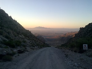
miniscule hints of joy by mt98dew   Overview OverviewPark at the Verrado Trail Head parking lot. Hike up to the old Caterpillar proving ground via N Tower Rd. Keep going on N Tower Rd until it winds up to the radio towers. Hike The trail/"road" is broad and straight, so it was more precautionary than anything. The trail heads north for the first 1.25 miles. Relatively flat, with some gradual twists and turns. At about 1.25 miles, the trail turns NW and starts a very steady straight climb for the next 1.5 miles. The incline is remarkably consistent (and boring, to be honest). There is no wondering "what's around the bend, or what is over the rise" because you can see everything in front of you.
The view from the top of this climb was pretty rewarding, though limited to the northwest valley. It was kind of neat seeing some of the "inner valleys" of the White Tanks. I still had a little over 3 miles to go to reach the radio towers. I had forgotten that the road didn't go directly to the towers but passes them on the west side. So I did a semi-circle in my approach to the summit. Even though this added mileage to the hike, I'm sure it made the overall climb more gradual. I was still wiped from the climb, so I stayed in hiking mode for most of this segment. This worked out well because it allowed catching sight of the javelina that crossed the road in front of me, as well as a good-sized owl a little later on. Sightings like that make even boring trails worthwhile. :) I reached the summit and signed in on the register. Surprise to see that there has been little activity this year. Only four parties have signed the register this year, the last being in March. The canister holding the register has moved since my last visit - they've added fencing around some of the towers - but the can containing the register is still easy to find. Check out the Triplogs. Note This is a moderately difficult hike. Leave No Trace and +Add a Triplog after your hike to support this local community. | |||||||||||||||||||||||||||||||||||||||||||||||||||||||||||||||||||||||||