 Route Editor

| Guide | ♦ | 5 Triplogs | 0 Topics |
details | drive | no permit | forecast | route |
stats |
photos | triplogs | topics | location |
| 13 | 5 | 0 |
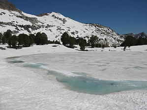
Rubywilubemine by AZLOT69 This hike starts at the roads end trailhead. There is ample parking and restrooms. The trail is at the south end of the parking lot and has a plaque engraved with a map of the trail with mileage. The distances are one way and generally are gauged by the arrival to different alpine lakes. This hike will take us to Lamoille Lake which is one of the larger alpine lakes. It was created by the carving of glaciers and is know as a tarn, a mountain lake. The steep terrain has you climbing right from the start and at a trailhead elevation of 8813 ft you might be feeling short of breath. Much of the Ruby Crest Trail is over 9500 ft. There are seasonal waterfalls generally well into summer and the mountain flowers begin in earnest during the month of July. As you gain altitude look back at the vast valley behind you. It seems to have you in a gigantic box canyon. Sheer cliffs of granite surround you as you top the first of many false summits. Ahead lie the first of three small lakes or tarns. These are called dollar lakes. Circular, like silver dollars, they are fed by snow melt and the granite lining keep them crystal clear with a beautiful blue color and are only about 15 feet deep. The hike continues over meadows and thru stands of White Bark and Limber Pine trees. The next false summit brings you to Lamoille Lake. Lamoille Lake is located at 9740 elevation and is about 13.5 acres. Bring a fishing rod and a picnic lunch for a fun afternoon before heading back the way you came. Check out the Official Route and Triplogs. Leave No Trace and +Add a Triplog after your hike to support this local community. One-Way Notice This hike is listed as One-Way. When hiking several trails on a single "hike", log it with a generic name that describes the hike. Then link the trails traveled, check out the example. | |||||||||||||||||||||||||||||||||||||||||||||||||||||||||||||||||||||||||||||||||||||||||||||


