Route Editor

| Guide | ♦ | 4 Triplogs | 0 Topics |
details | drive | permit | forecast | route |
stats |
photos | triplogs | topics | location |
| 69 | 4 | 0 |
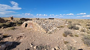
Where the Wild West Went Even Wilder by The_Eagle   Canyon Diablo, or "Devil's Canyon," is a rugged and historic ravine. This deep canyon once served as a significant point along the Santa Fe Railroad, connecting the western territories in the late 19th century. It is also renowned for the nearby Canyon Diablo Meteorite, believed to have caused the canyon's formation approximately 50,000 years ago, part of the same event that created Meteor Crater. Canyon Diablo, or "Devil's Canyon," is a rugged and historic ravine. This deep canyon once served as a significant point along the Santa Fe Railroad, connecting the western territories in the late 19th century. It is also renowned for the nearby Canyon Diablo Meteorite, believed to have caused the canyon's formation approximately 50,000 years ago, part of the same event that created Meteor Crater.The area was a hotspot for outlaws and bandits, resulting in numerous robberies and shootouts. The town of Canyon Diablo, established in 1880, earned a reputation as one of the wildest in the West, considered even more dangerous than Tombstone and Dodge City combined. Saloons, brothels, and gambling houses were open around the clock on "Hell Street."
Today, the canyon and the nearby town have faded into history. There is no established trail; you can explore the remnants as you choose. Several areas of ruins, the bridge, and Hermann Wolf's grave are still present, while many others found their final resting place in the town's "Boot Hill." Check out the Official Route and Triplogs. Leave No Trace and +Add a Triplog after your hike to support this local community. | ||||||||||||||||||||||||||||||||||||||||||||||||||||||||||||||||||||||||||||||