username
X
password
register
for free!
help


Ravens Nest, AZ

Guide 1 Triplog  0 Topics
  2 of 5  
Fav
Wish
0
details
drive
no permit
forecast
map
stats
photos
triplog
topics
location
4 1 0
HAZ reminds you to respect the ruins. Please read the Archaeological Resources Protection Act of 1979 & Ruins Etiquette
Statistics
tap row or icons for details
Difficulty 0.5 of 5
Distance Round Trip 0.5 miles
Trailhead Elevation 5,383 feet
Elevation Gain 55 feet
Accumulated Gain 55 feet
Kokopelli Seeds 0.78
 Interest Off-Trail Hiking, Ruins & Historic
feature photo
Photos Viewed All MineFollowing
4  2012-03-31 AZLOT69
Author
author avatar Guides 16,843
Routes 17,472
Photos 24
Trips 1 map ( 6 miles )
Age 28 Male Gender
Location HAZ, TrailDEX
Associated Areas
list map done
Northeast Region
Historical Weather
Trailhead Forecast
Expand Map
Preferred Apr, Oct, Mar, Nov
Sun  5:59am - 6:47pm
0 Route
 
0 Alternative


remove free decal offer
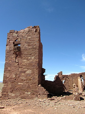
monocular optical instrument
by HAZ_Hikebot

 
Overview
During the heydays of Route 66, a man named D.M. Barringer built an observatory just off of the Mother Road so that the many travelers passing by the area could see the crater without having to travel the additional six or so miles to the site. For just 25 cents, travelers could stand from the observation tower and see the crater through a telescope. Today the observatory is nothing but stone ruins, occupied by ravens. Ravens Nest is an interesting structure and area to stretch your legs if in the area.


2018-07-14 HAZ_Hikebot


    Check out the Triplog.
    Leave No Trace and +Add a Triplog after your hike to support this local community.
    WARNING! Hiking and outdoor related sports can be dangerous. Be responsible and prepare for the trip. Study the area you are entering and plan accordingly. Dress for the current and unexpected weather changes. Take plenty of water. Never go alone. Make an itinerary with your plan(s), route(s), destination(s) and expected return time. Give your itinerary to trusted family and/or friends.

     Permit $$
    None


     Directions
    or
     Road
    Paved - Car Okay

    To hike
    I 40 east of Flagstaff Exit 233 south 1/4 mile, turn left just past campground on old route 66. Proceed 0.75 miles to the site on the left.
    page created by AZLOT69 on Apr 01 2012 5:20 pm
     90+° 8am - 6pm kills
    helpcorrectionissue

    end of page marker