Route Editor

| Guide | ♦ | 4 Triplogs | 0 Topics |
details | drive | permit | forecast | map |
stats |
photos | triplogs | topics | location |
| 53 | 4 | 0 |
Canyons are inherently risky. Flash floods occur without notice on sunny days. Technical skills & surrounding topography knowledge required yet does not eliminate risk.
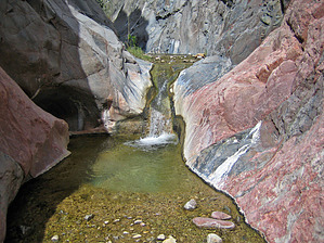
  Overview: Follows Grapevine Creek from the camping area down to the Colorado River and back. Non-technical, but there are several exposed scrambles to bypass waterfalls and other dropoffs (see Grand Canyoneering by Todd Martin for details). Overview: Follows Grapevine Creek from the camping area down to the Colorado River and back. Non-technical, but there are several exposed scrambles to bypass waterfalls and other dropoffs (see Grand Canyoneering by Todd Martin for details).Check out the Triplogs. Leave No Trace and +Add a Triplog after your canyon trip to support this local community. | ||||||||||||||||||||||||||||||||||||||||||||||||||||||||||||||||