username
X
password
register
for free!
help


Tatahatso Canyon, AZ

Guide 4 Triplogs  1 Topic
  4 of 5  
Fav
Wish
2
details
drive
permit
forecast
map
stats
photos
triplogs
topic
location
150 4 1
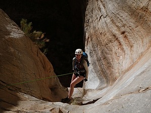
Canyons are inherently risky. Flash floods occur without notice on sunny days. Technical skills & surrounding topography knowledge required yet does not eliminate risk.
Statistics
tap row or icons for details
Distance Round Trip 14 miles
Trailhead Elevation 5,685 feet
Elevation Gain 3,000 feet
Kokopelli Seeds 29
 Interest Off-Trail Hiking, Seasonal Waterfall & Seasonal Creek
unreported if dogs are allowed
editedit > ops > dogs to adjust
feature photo
Photos Viewed All MineFollowing
17  2018-11-16
Tatahatso Canyon
RedwallNHops
150  2012-04-14 Vaporman
Author
author avatar Guides 16,843
Routes 17,472
Photos 24
Trips 1 map ( 6 miles )
Age 28 Male Gender
Location HAZ, TrailDEX
Historical Weather
Trailhead Forecast
Expand Map
Preferred Oct, Nov, Mar, Apr
Sun  6:01am - 6:51pm
0 Route
 
0 Alternative


remove free decal offer

  
2019-11-12
Access for this area is reported not allowed.

Overview
amAZing loop starting from the Eminence Break TH and following that geological fault NE towards Tatahatso Canyon and dropping into a cairned steep ravine down in the middle canyon. After much down climbing & boulder hopping, you'll eventually reach the challenging lower narrows with over a handful of awkward rappels up to 75ft. Once you reach the river, be prepared to spend the night and navigate down the river 7 miles back to the Eminence Break trail. I highly recommend doing the nearby Tatahosa Canyon that afternoon and hiking out that steep exposed trail the next shady morning. =)

2018-07-14 HAZ_Hikebot
  • Grand Canyon Use Area Boundaries - Dynamic Map


Check out the Triplogs.
Leave No Trace and +Add a Triplog after your canyon trip to support this local community.
WARNING! Hiking and outdoor related sports can be dangerous. Be responsible and prepare for the trip. Study the area you are entering and plan accordingly. Dress for the current and unexpected weather changes. Take plenty of water. Never go alone. Make an itinerary with your plan(s), route(s), destination(s) and expected return time. Give your itinerary to trusted family and/or friends.

 Permit $$
Special Use

Special
Navajo permit to drive to trailhead, overnight if leaving vehicle overnight.

No NPS entrance fee. NPS backpacking permit required to camp below the rim.

Navajo Nation Reservation
Navajo Permits & Services
navajonationparks.org

Grand Canyon National Park
Details for each are occasionaly below numerous alerts
Entrance Fee
Overnight/Backpacking Permits
Grand Canyon Use Areas Map
Rim-to-Rim and Extended Day Hike/Run


 Directions
or
 Road
High Clearance possible when dry

To canyon trip
From AZ89 in Cedar Ridge, turn west on 6110 and follow the maze of roads to the Eminence Break TH
page created by Vaporman on Apr 20 2012 7:06 pm
 90+° 8am - 6pm kills
helpcorrectionissue

end of page marker