 Route Editor

| Guide | ♦ | 9 Triplogs | 1 Topic |
details | drive | no permit | forecast | map |
stats |
photos | triplogs | topic | location |
| 21 | 9 | 1 |
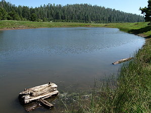
Little Bo Peep by hippiepunkpirate  Although no signage actually bears its name, Little Gnarly was lovingly christened by the local mountain bikers who use it to form a popular biking loop in conjunction with portions of the Rocky Ridge, Schultz Creek, and Brookbank Trails. For hikers, the Little Gnarly can be used as an excellent route to the beautiful meadows within the Dry Lake Hills interior. Lost Burrito is the access route to the meadows of the dry lake. The name "Lost Burrito" has some mountain biking legend behind it, but not being much of a mountain biker myself, I can't give a real good tale about it. Much of the Little Gnarly and Lost Burrito are two-track forest service jeep trails that are now closed to motor vehicles. Although no signage actually bears its name, Little Gnarly was lovingly christened by the local mountain bikers who use it to form a popular biking loop in conjunction with portions of the Rocky Ridge, Schultz Creek, and Brookbank Trails. For hikers, the Little Gnarly can be used as an excellent route to the beautiful meadows within the Dry Lake Hills interior. Lost Burrito is the access route to the meadows of the dry lake. The name "Lost Burrito" has some mountain biking legend behind it, but not being much of a mountain biker myself, I can't give a real good tale about it. Much of the Little Gnarly and Lost Burrito are two-track forest service jeep trails that are now closed to motor vehicles.The Schultz Loop (formed by a portion of Schultz Creek Trail on the north, a portion of Little Gnarly on the west, and an access trail from the Sunset Trailhead on the east) is the 1.6-mile triangle actually shown on the signage for the area. We are not really interested in the Schultz Loop itself, but the eastern access trail, which connects the trailhead to Little Gnarly.
My Recommended Hike: From the Sunset Trailhead, you will notice the Sunset Trail rambling off into the forest to the east and the Schultz Creek Trail going the opposite direction. For the route, we are looking for, head south on Schultz Loop. A few hundred feet ahead is a gate, which you will pass through. An unmarked trail will soon show itself but bear right as indicated by the "Trail" marker. This unmarked trail leads to an interconnecting series of mountain biking trails and is quite interesting to explore, but I recommend familiarizing yourself with the area first. Anyway, pass the unmarked trail, and soon you will come across the junction with the Little Gnarly. Continue south on Little Gnarly, and the many large rocks dominating the trail will give light as to why mountain bikers call this Little Gnarly. 1.6 miles into the hike is a fenced-in pond with the meadows of the Dry Lake Hills beyond. Here lies an unsigned fork in the road. Should you bear left, Little Gnarly continues for 0.4 miles until it ends at the Brookbank. Explore this option later. Bear right on the unmarked trail, the Lost Burrito. After just a few steps is ANOTHER unmarked fork. Bear left to follow the two-track trail along the fence for easier route finding. On your left, you will notice a gate in the fence where you can check out the pond. Yet another crossroads in the middle of the meadow. Follow the trail that veers just left of a lone dying pine tree. This tree will cast shade on nearby boulders and is a great place to relax and enjoy the meadow if you come around noon. Continue down the trail to yet another unmarked fork. To bear right would continue down the Lost Burrito farther into the Dry Lake Hills. Still, I recommend bearing left and continuing up back into the forest and out to a great rocky viewpoint that looks down upon McMillan Mesa and East Flagstaff. The distance listed is for this specific route out the viewpoint and back to the trailhead, but the numerous other side-trail journeys could add miles to the hike, not to mention creating loops with the Brookbank, Schultz Creek, and Sunset trails. I met a guy at the viewpoint who had hiked from Buffalo Park up the Oldham to the Brookbank and then up the Lost Burrito to where we met. That option is about 10 miles round trip with about 1,400 feet of average elevation gain. These trails are not shown on the map from the Forest Service website, so I will try to get a good map up soon. Gate Policy: If a gate is closed upon arrival, leave it closed after you go through. If it is open, leave it open. Leaving a closed gate open may put cattle in danger. Closing an open gate may cut them off from water. Please be respectful, leave gates as found. The exception is signage on the gate directing you otherwise. Check out the Triplogs. Leave No Trace and +Add a Triplog after your hike to support this local community. One-Way Notice This hike is listed as One-Way. When hiking several trails on a single "hike", log it with a generic name that describes the hike. Then link the trails traveled, check out the example. | |||||||||||||||||||||||||||||||||||||||||||||||||||||||||||||||||||||||||||||||||||||||


