 Route Editor

| Guide | ♦ | 9 Triplogs | 0 Topics |
details | drive | permit | forecast | map |
stats |
photos | triplogs | topics | location |
| 153 | 9 | 0 |
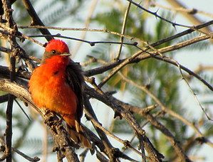
 Overview OverviewA nice hike through mesquite bosque, Cottonwood, and willow-lined river banks. This area has many opportunities for wildlife viewing and birding. Both land and shorebirds inhabit this area. The main trail meanders South along the Agua Fria as it ties into Lake Pleasant. 2000 ft mesa's surround this area that is inhabited by Eagles and Vultures. A typical round trip is 3.30 to 4.00 miles. Depending on how high the water levels are along the lake, some areas will be inaccessible. Check out the Triplogs. Leave No Trace and +Add a Triplog after your hike to support this local community. One-Way Notice This hike is listed as One-Way. When hiking several trails on a single "hike", log it with a generic name that describes the hike. Then link the trails traveled, check out the example. | |||||||||||||||||||||||||||||||||||||||||||||||||||||||||||||||||||||||||||||||||||||||||||||||||||||||||||||||||||||||||||||||||||||||||||||||||||||||


