 Route Editor

| Guide | ♦ | 14 Triplogs | 0 Topics |
details | drive | permit | forecast | 🔥 route |
stats |
photos | triplogs | topics | location |
| 7 | 14 | 0 |
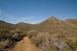
A taste of Big Bug by JoelHazelton   Rationalization RationalizationI've been very curious about the Big Bug Mesa area lately for a couple of reasons. First of all, I've found very little info on hiking in the area. Any trail write-ups I've come across were limited to Grapevine Spring and a small, vague description of this hike. Second of all, and more importantly, it seems to be the quickest access to ponderosa pines from the west side of Phoenix. This, of course, may be incorrect, but I know roundtrip I used significantly less than half of a tank of gas coming from the Glendale area. I can't complain about that! Hike The hike begins on a jeep track and passes several nice campsites in the first short stretch in the shade of huge pine trees. After about 0.25 miles you may spot a sign on the left (west) side of the creek that says "9345". Ignore the sign and continue straight on the trail on the right side of the creek. Soon the trail leaves the cool creekbed and climbs over some small hills and in and out of a couple of washes as it passes the mouth of Pipeline Canyon. At mile 1.1 you enter the shade of some tall pines and encounter an old corral. This is a good cool-down spot if you decided to hike on a 90+ degree day as we did. Soon the trail leaves the shade but re-enters at mile 1.35. This short stretch in the bottom of the canyon is very enjoyable. The pines are tall and the shade is cool, and the crunch of pine needles under your feet is relaxing. Enjoy, because you will quickly exit the shade and commence fighting through overgrown scrub oak and manzanita as the trail deteriorates. They are small cairns at many of the creek crossings, red flagging on the trees, and eventually a barbed wire fence on your right to help keep you on the trail.
Summary We did not encounter a single person on this hike on a Saturday afternoon. Awesome! I would certainly recommend this hike for solitude, a decent workout, a variety of terrain, decent views, and proximity to Phoenix. It would probably be perfect when the creek is running... Just be aware, it is very warm during the summer. Check out the Official Route and Triplogs. Leave No Trace and +Add a Triplog after your hike to support this local community. One-Way Notice This hike is listed as One-Way. When hiking several trails on a single "hike", log it with a generic name that describes the hike. Then link the trails traveled, check out the example. | |||||||||||||||||||||||||||||||||||||||||||||||||||||||||||||||||||||||||||||||||||||||||||||||||||||||||||||||||||||||||||||||||||||||||||||||||||||||||||||||||||||||||||||||||||||||||||||||||||||||||||


