 Route Editor

| Guide | ♦ | 5 Triplogs | 0 Topics |
details | drive | no permit | forecast | route |
stats |
photos | triplogs | topics | location |
| 11 | 5 | 0 |
Where Do I Start?? by imike The trail may be accessed directly from Forest Road 64, or from an intersection near the Trailhead for Hubbell Canyon Trail at it's upper end.
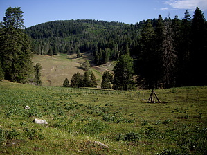
The area is filled with both conifers and aspen trees... nicely green in season, colorful in the fall. Elk fill the area. Head out early or late in the day and you will encounter numerous herds. Deer and Turkey are common. Black Bears roam the ridges. This is also an area in steady weekend use by ATV advocates. The trail is open to motorbikes and four wheel off road vehicles. Mountain biking, horse back riding and hiking are also allowed. The softly graded double track is best for the mountain bike. Come during the week and you will probably have the trail all to yourself. The forest is often closed during fire season: May thru June, depending on conditions. Even if it is open, if you camp during those months be aware of the potential dangers and plan accordingly. There is good car camping just off of Forest Road 64, and you will be close to the Sunspot Observatory with it's arrays and Visitor Center (complete with snacks and drinks!) These high canyon trails, with their open, marshy meadows are filled with the remnants of the old railway lines, with rotting trestles and rock bound bed cuts. You can still gather bits of coal left lying around from the train activity. What I particularly like about the area is that unlike similar meadow hikes over in Colorado, there will not be ten cars at every trail head, nor 20 other hikers out on the trails. Cattle are free ranged in the area; purify any water used. The trailhead orientation is the one most easily found, noted as an alternative leg of the trail in the local hiking guide book. If you choose to start at the higher, higher end, begin your hike at the trailhead for Hubbell Canyon Trail, or park at the easier to find point on FR 64, walk in, turn right and follow the trail up to the upper point.
Check out the Official Route and Triplogs. Leave No Trace and +Add a Triplog after your hike to support this local community. One-Way Notice This hike is listed as One-Way. When hiking several trails on a single "hike", log it with a generic name that describes the hike. Then link the trails traveled, check out the example. | ||||||||||||||||||||||||||||||||||||||||||||||||||||||||||||||||||||||||||||||||||||||||||||


