 Route Editor

| Guide | ♦ | 1 Triplog | 0 Topics |
details | drive | no permit | forecast | route |
stats |
photos | triplog | topics | location |
| 15 | 1 | 0 |
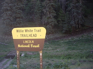
Downhill Can't Be All Bad! by imike The portion designated as the official trail drops from the junction of the New Sunspot Hiway and Forest Road 64....for .7 miles down the roadbed, but for all practical purposes, the entire section down to Rio Penasco Rd. (Forest Road 164) might as well be considered the "trail". Even the portion not factored as the forest trail 5009, is given the designation Forest Road 5009. So, 3.25 miles covers that entire length.
At mile 2.5 down canyon, you encounter Trail 113, Willy White Trail. That trail takes off steeply uphill in the narrow Telephone Canyon, to loop around to Bluff Springs, connecting with trail 5008, Willis Canyon Trail and connecting with the decommissioned timber road,6411, that follows the ridge back up and around to Forest Road 64. This old road bed is the best hiking in the area, reaching a high point of close to 9600'... and it is closed to ATV traffic! Consider combining t5009, t113 with this old road bed for a nice 10 mile loop. Since the lower section of T5009 is designated as a road, it is available for car camping. You can access off of FR164 and drive the fairly nice gravel road well up into the canyon. In wet years, there will be some small springs filling the bottom of the meadow marshes. This trail is a very popular off road vehicle route. An interesting alternative to hiking this canyon is to walk down into the bottom of the drainage and hike the meadow like cattle trail , instead of the gravel road bed. It is a good idea to check out a map to note the various connecting options available from this canyon, especially those old roadbeds oriented up range to the south. The rating for difficulty is based on the altitude and the fact that unless you have a shuttle set up, you will have to hike back up to your car, for better or worse. This trail is an excellent route for a downhill mountain bike run! Check out the Official Route and Triplog. Leave No Trace and +Add a Triplog after your hike to support this local community. One-Way Notice This hike is listed as One-Way. When hiking several trails on a single "hike", log it with a generic name that describes the hike. Then link the trails traveled, check out the example. | |||||||||||||||||||||||||||||||||||||||||||||||||||||||||||||||||||||||||||||||||||||||||


