Overview
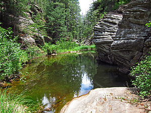
Middle Bear Canyon is defined as the "off-trail" section from where one enters the canyon at the coordinates noted below to Bear Canyon Upper where the canyon splits with East Bear Canyon. This hike as now written is an "out and back" (~5.3 miles one way) but could also be a loop or shuttle hike if an adequate upper Bear Canyon hike exit route and TH Parking location are later determined. Middle Bear Canyon "off-trail" hiking can be compared to hiking sections of our Mogollon Rim- Barbershop Canyon and Dane Canyon.
Hike Start: from TH Parking, hike NW crossing FR139A following Fred Haught Trail#141. Enter into Middle Bear Canyon (down east side) at where Trail#141 crosses Bear Canyon on FR95 (at 34.509706 -111.200924).
Also Note: For the stronger hiker with off-trail route-finding ability, this Bear Canyon(Middle) hike description can be combined with the Bear Canyon(Upper) hike description for a longer 10+ mile shuttle hike.
WARNING! Hiking and outdoor related sports can be dangerous. Be responsible and prepare for the trip. Study the area you are entering and plan accordingly. Dress for the current and unexpected weather changes. Take plenty of water. Never go alone. Make an itinerary with your plan(s), route(s), destination(s) and expected return time. Give your itinerary to trusted family and/or friends.
Permit $$
None
Directions
Road
High Clearance possible when dry
To hike From the Phoenix Area- Hwy 87 North through Payson, Pine, Strawberry, and Clint's Well. Just past the Blue Ridge Ranger station on Hwy 87, turn right (east) onto Forest Road 95. Follow Forest Road 95 for approximately 11.15 miles, then turn left (south) onto Forest Road 139A. Follow Forest Road 139A for a little over 0.1 miles to the signed crossing (on the left side) of the Fred Haught Trail #141. There is a small parking area here and a large trail sign. This is also the Parking and TH Start location for access to the Pinchot Cabin location.
page created by Grasshopper on Jun 12 2012 8:09 pm
 Route Editor


 Overview