 Route Editor

| Guide | ♦ | 2 Triplogs | 0 Topics |
details | drive | no permit | forecast | map |
stats |
photos | triplogs | topics | location |
| 18 | 2 | 0 |
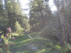
No ATV's!! by imike The old logging road bed offers some shady protection, often wandering up and into the timber above the canyon bottom. It also crosses a number of active springs. The largest forming a bit of a marshy crossing, ripe with the assortment of hoof prints representing the animal life taking advantage of the running water. I spotted deer, elk, turkey and cat... along with cattle prints.
At 1.5 miles into the hike, just around the bend from the larger spring/seep, there are a number of old gate posts... if you exit the logging road to your left at this point you will walk up by a gurgling spring, and if you follow the tilted bench up and around, you will eventually come out above the seep you crossed earlier. At this point you can move off to your right, following a well used elk trail... that will carry you up into a "Sherwood Forest" setting of close, tall pines and firs, intermixed with moss covered rocks. This terminus of a rock slide marks the base of the cliffs that were visible from early on in the hike, and provide a great spot for taking a break. This .2 mile side trek is well worth the time and effort. Walking the .2 tenths of a mile back to the main logging road, you will then enjoy a nicely tree shaded section. Unfortunately, there is only .5 miles of trail left to enjoy. If you follow the upper logging road, it winds around and out of the canyon, terminating up in Water Canyon along the Old Sunspot Hiway (FR5009). If you follow the split to the right, it will drop you down into the bottom of Brown Canyon... where you can follow the track down and around into Water Canyon... or slope back up to connect with that upper logging road track (it loops). These routes make for great looping connections, including an off trail potential back up to the old logging road (6411) that will wind you back around to the starting point on FR 64. Gate Policy: If a gate is closed upon arrival, leave it closed after you go through. If it is open, leave it open. Leaving a closed gate open may put cattle in danger. Closing an open gate may cut them off from water. Please be respectful, leave gates as found. The exception is signage on the gate directing you otherwise. Check out the Triplogs. Leave No Trace and +Add a Triplog after your hike to support this local community. One-Way Notice This hike is listed as One-Way. When hiking several trails on a single "hike", log it with a generic name that describes the hike. Then link the trails traveled, check out the example. | ||||||||||||||||||||||||||||||||||||||||||||||||||||||||||||||||||||||||||||||||||||||||||


