Route Editor

| Guide | ♦ | 41 Triplogs | 1 Topic |
details | drive | no permit | forecast | 🔥 route |
stats |
photos | triplogs | topic | location |
| 585 | 41 | 1 |
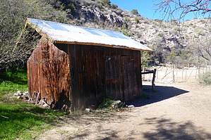
Little House on the Creek by AZWanderingBear   Overview OverviewThe trail is rocky and uphill both ways, but the payoff is a well-preserved cabin and a nice hike along Lime Creek. Warning So that you know, there is no cell phone service. The only way back home is up that rocky trail you came down.
Once you turn off Seven Springs Road, FR254 and then FR1094 are privately maintained. When I did this hike, both were in very good condition. However, some rain can turn the drive to the trailhead into a muddy mess. There are several wash crossings, and I wouldn't enter any of them if they were flooded. Having said all that, a vehicle with reasonable clearance and 2WD can make the trailhead most of the time with no problems. As you depart the trailhead, the path follows along a wash for a short way and then begins a reasonably easy climb up to a saddle. The saddle is home to a gate through a drift fence and also the highest point of your hike. It is 1.3 hiking miles from the trailhead, and you'll be praying you get back to it on the hike out. From the saddle, you begin a 2.7-mile descent into Lime Creek. The trail is primarily comprised of loose rocks that vary from baseball size to football size. The footing just isn't going to be good until you get to the creek. Watch your step. Views are decent on the way down with Humbolt and its desert snowball off to your right, Sunset Mountain straight ahead, and Four Peaks and Mount Ord off in the distance. About 2.6 miles in, you will pass some ruins on the right side of the trail. Just look for a very low rock wall. There are many other ruins scattered about in this area. At one time, it must have been a thriving Hohokam community. At approximately 3 miles, the trail crosses the first of two very rocky washes. Just make sure to look for the trail exiting out of the wash straight across. While you could probably hike down the wash, it definitely wouldn't be advisable. About 3.7 miles in, you will see a very weathered trail sign attempting to point to the old smelter downstream from the cabin and also to the Verde River. Stay left to head to the cabin. Once you drop into Lime Creek, at about the 4.2-mile point, look for the horse trail. It crosses the creek to the north side about 150 feet from where you drop in. There are faded marker ribbons where the trail crosses the creek, but the horsemen who use this trail also put shiny aluminum cans up in the trees about head high, that is, head high if you are on a tall horse, so look up. If you lose the trail, bushwhack upstream. The cabin is about 0.8 miles up that way on the left. You won't miss it. Not too sure about the origins of the cabin. It looks like a line shack from a ranch that operated in the area. The cabin, storage shed, and corrals are being maintained by a riding club that uses them occasionally. The cabin has some supplies inside. A fire ring with a grill, some old bedsteads, and a table with some cook pots are nearby outside. The storage shed has Cartwright Bros., and 1882 painted on the front. Not sure Hoss and Little Joe were ever here, and pretty certain tin-sided sheds weren't around in '82. But this area did have small ranches and mining concerns around that time frame. All-in-all it is just a cool place. Enjoy it before you begin the long slog back up the rocky trail. Water Sources Lime Spring is located just east of the cabin and is a reasonably reliable water source. Camping Camping at the cabin would be pretty easy given the resources that are already there. But toting a backpack up to the trailhead would not be for the faint of heart (or perhaps lungs). Gate Policy: If a gate is closed upon arrival, leave it closed after you go through. If it is open, leave it open. Leaving a closed gate open may put cattle in danger. Closing an open gate may cut them off from water. Please be respectful, leave gates as found. The exception is signage on the gate directing you otherwise. Check out the Official Route and Triplogs. Leave No Trace and +Add a Triplog after your hike to support this local community. | |||||||||||||||||||||||||||||||||||||||||||||||||||||||||||||||||||||||||||||||||||||||||||||||||||||||||||||||||