Route Editor

| Guide | ♦ | 17 Triplogs | 0 Topics |
details | drive | no permit | forecast | 🔥 route |
stats |
photos | triplogs | topics | location |
| 126 | 17 | 0 |
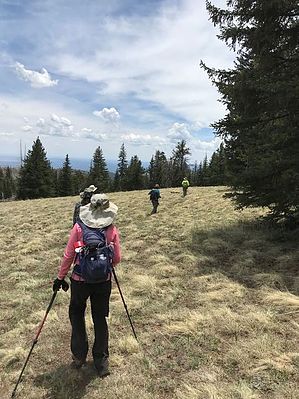
Go for the Gusto - Hike Schultz! by DixieFlyer  Overview OverviewSchultz Peak(elevation of 10,083' with 103' of prominence) is in the Kachina Peaks Wilderness north of Flagstaff and is 1.3 miles SE of Doyle Peak. Hike No trails access Schultz Peak, so you'll need to do some off-trail hiking to get there. The "official" route in this guide documents an out-and-back hike from Schultz Tank that goes a short distance on Waterline Road and then goes off-trail northward up to Schultz Peak. While this is a straightforward way to get up to Schultz Peak, it involves a steep and strenuous climb.
An interesting part of the hike is the section from the Schultz Peak summit to High Tank, which is southeast of the summit. On this portion of the hike, you'll be going through a delightful high alpine meadow. As you get close to High Tank, you'll pass through a boneyard which is littered with bones from deer and/or elk who no doubt were prey for mountain lions. Warning Much of the hike is off-trail, portions of which are on some steep and slippery slopes. As such, inexperienced hikers or those unaccustomed to off-trail hiking should exercise caution. History According to Wikipedia, until sometime in the 1930s, what is now known as Doyle Peak was named Schultz Peak. At that time, Doyle Peak was the name given to the ridge west of Fremont Peak, and modern-day Schultz Peak had no name. Perhaps this is why many maps show "Doyle Saddle" as the saddle between Fremont Peak and Agassiz Peak and "Fremont Saddle" as the saddle between Fremont Peak and present-day Doyle Peak.
Check out the Official Route and Triplogs. Note This is a moderately difficult hike. Leave No Trace and +Add a Triplog after your hike to support this local community. | ||||||||||||||||||||||||||||||||||||||||||||||||||||||||||||||||||||||||||||||||||||||||||||||||||||||||||||||||||||||||||||||||||||||||||||||||||||||||||||||||||||||||||||||||||||||||||||||||||||||||||||||||||||||