 Route Editor

| Guide | ♦ | 1 Triplog | 0 Topics |
details | drive | no permit | forecast | map |
stats |
photos | triplog | topics | location |
| 7 | 1 | 0 |
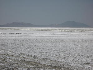
Grim Reaper Real Estate by AZLOT69  The California Trail, Carson River Route is clearly marked along U S Highway 95 south of Interstate 80. Our hike starts here. You can clearly see the old roadbed as it runs diagonally across the highway and thru the desert. To the east lies the Humboldt sink, a playa covered with salt and to the west is the 40 mile desert. Flat and featureless with nothing more than a little scrub for plant life. Entering the 40 mile desert the hike starts to the southwest heading towards double wells, a settlement that developed on the edge of the desert due to the availability of limestone is this area. The earth crunches at every step and an impression of your foot remains. Its kind of like walking on a beach in sand. It definitely slows your pace. While this stretch of trail can be driven it would be strictly 4 X 4 and do not attempt it by yourself. Have safety equipment such as a winch is a must. There are several areas where the ground is so soft you would easily get stuck. At about 1 mile there is another historical marker in the form of a sculptured railroad rail marking the location of double wells. A half mile further is the ruins of a limestone kiln. The kiln was built out of necessity. After roasting the limestone to a powder it can be used to neutralize the acidity in the local water. Lime was also used as a building material and an ingredient in making glass. After admiring the ingenuity of the pioneers continue on to the salt creek crossing then return the way you came. Check out the Triplog. Leave No Trace and +Add a Triplog after your hike to support this local community. One-Way Notice This hike is listed as One-Way. When hiking several trails on a single "hike", log it with a generic name that describes the hike. Then link the trails traveled, check out the example. | |||||||||||||||||||||||||||||||||||||||||||||||||||||||||||||||||||||||||||||||||||


