 Route Editor

| Guide | ♦ | 6 Triplogs | 0 Topics |
details | drive | permit | forecast | route |
stats |
photos | triplogs | topics | location |
| 6 | 6 | 0 |
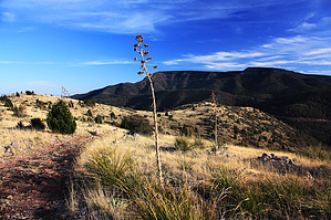
Woodchute's colorful connector by PrestonSands   Overview OverviewForest Road 500E is a steep, narrow, and rocky road northwest of Jerome that is better suited to hiking than driving. It climbs the northeastern slopes of Woodchute Mountain, connecting Perkinsville Road with Forest Road 503A (the Jerome-Prescott Wagon Road hike). This trail's position high on a mountainside allows unobstructed views of the surrounding area, including the Sycamore Canyon and Sedona areas. The name Section House Trail is my suggestion for this nameless Forest Road due to its location near Section House Spring. Statistics listed for this hike are for a one-way, uphill hike; a round trip hike will be about 6 miles with 1131 aeg.
The section of Perkinsville Road at the beginning of this hike was once the roadbed for the United Verde and Pacific Railroad, constructed in 1894 to serve the United Verde Mine in Jerome. Section House Spring, located nearby, was named for a railroad section house located there that housed a track maintenance worker. The railroad was removed in 1920. Limestone, used in the smelting process at the long-vanished Jerome smelter, was mined at the quarry near the beginning of FR 500E and hauled by railroad cars to the United Verde Mine (the abandoned open-pit mine passed on the drive in). A second limestone quarry is visible high on a mountainside above the trail. Hike Once you have located the unsigned beginning of Forest Road 500E, start up its steep and rocky route. FR 500E climbs the side of a brushy canyon at first, through exposures of grayish Redwall Limestone and brick red Supai Formation. The road climbs steadily higher on the slopes of Woodchute Mountain before essentially leveling out on top of a flat, open ridge at 6300 feet. A spur road heading out across the flat likely leads to the second limestone quarry. Beyond the flat, the road begins crossing a series of small ridges covered with scrub oak and agave, separated by shallow ravines filled with shrubby oaks and maples. Scattered oaks and pines begin to appear as well. The relatively open terrain on the mountainside allows for far-reaching views across the Verde Valley. Rounding point 6872, one can look down onto the Gold King Mine Museum, an interesting collection of buildings, machinery, and artifacts from the old west, some 1000 feet below. Once Forest Road 500E gains the rocky, open crest of Woodchute Mountain's prominent eastern ridge, the end is near. Mingus Mountain appears ahead, and the road makes a short descent through an agave wonderland to its end at an unsigned junction with Forest Road 503A, the route of the historic Jerome-Prescott Wagon Road. One can continue on FR 503A or return the same way. Check out the Official Route and Triplogs. Leave No Trace and +Add a Triplog after your hike to support this local community. One-Way Notice This hike is listed as One-Way. When hiking several trails on a single "hike", log it with a generic name that describes the hike. Then link the trails traveled, check out the example. | |||||||||||||||||||||||||||||||||||||||||||||||||||||||||||||||||||||||||||||||||||||||||


