Route Editor

| Guide | ♦ | 2 Triplogs | 0 Topics |
details | drive | permit | forecast | map |
stats |
photos | triplogs | topics | location |
| 18 | 2 | 0 |
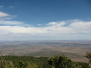
Isolated Laccolithic Gem by Jim Most of the drive in is paved, and it is only the last 2 miles or so that are dirt. I got my car to the trailhead, so you really should not have any trouble getting to the hike, or near enough to hike from very close to a paved surface. Surprisingly, there is cell service, so if you run into trouble you'll have that small comfort. The over all hiking trail is a pretty good dirt road to the summit. It is probably the only access trail to the top, and locals tell me it is the the old "War God Springs" trail, as the road passes a spring of that name. Perhaps in the past there was a different trail, or maybe an old sheep/ cattle trail that was expanded to produce the road, but either way the terrain around 90% of the mountain is so steep and rugged the road accesses the only large ramp to the top, and therefore it is logical to assume this is the only way to access the mountain. One could drive to the summit in a high clearance vehicle, but why drive out here not to hike?
Above the pure pine, you progress into a mixed conifer forest that transitions rapidly to a spruce-fir forest with a heavy aspen component. Views are non-existent, and hiking through here to the top is either for fall color that should be quiet impressive, or to claim the summit. The hike is pretty enjoyable. Arriving on the summit is a little bit anti-climatic. Still, you have arrived. I imagine it was what Mount Elden was like before the June 1977 Radio Fire. There are towers, and some slim views through the forest, but nothing that great. There is no fire tower for an expansive view. It could use that. Return the way you came. Elevation gain and AEG will depend on your parking location. There are a few spots where elevation is lost, so I added in some conservative extra for the AEG total. There are mileage markers on the road, and it appeared to be 5 miles from the parking area to the top. This would be a good hike for a high quality synced GPS track just to see what the data looks like, but then what longer hike isn't? You will probably see no one else out here, and you'll want to plan accordingly. It may have a hunter component in fall, as there were tracks on the road. Check out the Triplogs. Leave No Trace and +Add a Triplog after your hike to support this local community. | |||||||||||||||||||||||||||||||||||||||||||||||||||||||||||||||||||||||||||||||||||