Route Editor

| Guide | ♦ | 13 Triplogs | 0 Topics |
details | drive | permit | forecast | route |
stats |
photos | triplogs | topics | location |
| 15 | 13 | 0 |
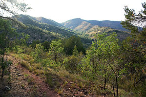
Oso wild on the north slope by PrestonSands   Overview OverviewThe Powerline Trail #549 is a dead-end trail that contours high along Mingus Mountain's forested north slope, south of Jerome, Arizona. One can expect solitude on this trail, whose route entirely follows an old, closed road. This is bear country, so be alert. Lacking its own trailhead, the Powerline Trail can be accessed from the Bug Hollow Trail #548, Mescal Trail #547, or the Upper Mescal Trail #550. The hike statistics listed above are for the Powerline Trail only. The shortest access to the Powerline Trail is via the lower (and unmarked) end of the Bug Hollow Trail, which requires a 1.35-mile hike from Highway 89A. The easiest (preferred) access is via the upper end of the Bug Hollow Trail, which requires a 1.9-mile hike from Highway 89A.
From its junction with the Bug Hollow Trail, the Powerline Trail, marked by a "549" signpost, begins a steady climb up the side of a ponderosa studded ridge, along the route of a long-closed road. The route makes a switchback over to the west slope of the ridge before surmounting its flat, boulder-covered crest. Turning east, the road begins to fade a bit but one can still see the level shelf of the old roadbed carved from the mountainside. Cairns mark the way. For the next mile or so, the trail contours its way east along the steep, forested, northern slope of Mingus Mountain. Locust and other shrubs cover the route of the road but a continuous path still exists. A few ravines along the way shelter bigtooth maples, white firs, and Douglas firs. A couple of small ridges allow views to the north through the trees. About a mile and a half in from the Bug Hollow Trail, the Powerline Trail rounds a ridge where one has a pretty good view of the Verde Valley. This is where most will likely want to turn around, as the remaining half-mile of the Powerline Trail gets a bit more overgrown. If you decide to continue, the trail turns south onto a more open, east-facing slope, which forms one side of a large forested bowl. As it nears its end, the Powerline Trail descends a bit into a ravine, where it suddenly dead-ends among tall pines. Aside from returning the same way, one can turn this hike into a loop by continuing off trail down the ravine for a half-mile to where it crosses the North Mingus Trail #105. A left turn onto the North Mingus Trail will take you back to Highway 89A and the bottom end of the Bug Hollow Trail. Having a topo map or GPS is helpful for this option. Check out the Official Route and Triplogs. Leave No Trace and +Add a Triplog after your hike to support this local community. | ||||||||||||||||||||||||||||||||||||||||||||||||||||||||||||||||||||||||||||||||||||||||||||||||||||||||||||||||||||||||||||||||||||||||||||||||||||||||||||||||||||||||||||||||||||||||||||||||||