Route Editor

| Guide | 0 Triplogs | 0 Topics |
details | drive | permit | forecast | route |
stats |
photos | triplogs | topics | location |
| 31 | 0 | 0 |
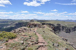
Angels Landing on Steroids by slegal The Devil's Causeway is a rock ledge that spans a narrow gap between two ridge lines. For those that are familiar with Angels Landing in Zion National Park, Devil's Causeway can best be described as Angels Landing on steroids. First, Angels Landing has chains to hold onto and for the most part, the sandstone is pretty smooth. Devil's Causeway has nothing to hold onto, unless you go across on all fours like many do. Second, Angels Landing tops out at 5,790 feet above sea level while Devil's Causeway is 11,870 feet - more than twice as high. They are both narrow on the flat part, but with the rough basalt surface of Devil's Causeway, the four foot width seems awfully narrow considering the 1,000 feet of exposure on either side.
The trailhead is located at the end of a dirt forest service road called Bear River Rd. The drive up is beautiful, with a mix aspens, pines, fir and spruce. The trailhead is adjacent to the Stillwater Reservoir the trail travels alongside the Stillwater Reservoir for about seven-tenths of a mile until reaching the trailhead to Devil's Causeway. The trail is marked "East Fork Trail No 1119". There is no mention of Devil's Causeway on the sign. If you're like me and use a GPS with topo maps to navigate, you topo maps will probably keep you on the "Bear River Trail No 1120". You can get to the causeway this way, but you'll be taking on an additional 4 miles or so to the hike. The trail starts heading uphill at a gentle pace. There are several ponds along the way, lots of wildflowers and thick forest until you reach Little Causeway Lake at the 10,761' elevation. At the junction with the trail to the lake the trail to Devil's Causeway becomes steeper with lots of pumice and basalt on the trail. There are still lots of wildflowers, but trees become sparse. The trail travels about a quarter ways around the lake before leaving the lake behind for a high alpine meadow that leads to a set of long steep switchbacks. The switchbacks end in an intersection with the Devil's Causeway Trail, which is unmarked. The trail is identified be the fact that it is the only one that continues to head uphill from the intersection. This is also the steepest part of the hike. After reaching the top of the trail, the trail flattens out to a slight downhill toward the Devil's Causeway. As the trail approaches the Devil's Causeway the ridgeline becomes thinner and thinner. Just getting to the actual causeway may be unnerving enough, but then you get to the causeway itself. Many people won't cross it. I am one. Others will cross in on all fours or squatting very low. Some, like my son, will walk across upright as though walking down a flat sidewalk. Whether you go across the causeway or stay back and watch others cross it, you should come away from this hike satisfied because of all the views you will see through the hike. Check out the Official Route. Note This is a moderately difficult hike. Leave No Trace and +Add a Triplog after your hike to support this local community. | ||||||||||||||||||||||||||||||||||||||||||||||||||||||||||||||||||||||||||||||||||