username
X
password
register
for free!
help
 This is likely a great time to hike this trail!  Check out "Preferred" months below, keep in mind this is an estimate.
  

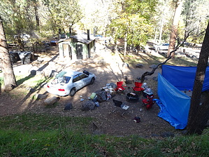
Manzanita Campground, AZ

Guide 0 Triplogs  0 Topics
  0 of 5  
Fav
Wish
0
details
drive
permit
forecast
map
stats
photos
triplogs
topics
location
0 0 0
Statistics
tap row or icons for details
Trailhead Elevation 4,815 feet
 Dogs not allowed
feature photo
Post the 1st photoset!
Author
author avatar Guides 16,843
Routes 17,472
Photos 24
Trips 1 map ( 6 miles )
Age 28 Male Gender
Location HAZ, TrailDEX
Historical Weather
Trailhead Forecast
Expand Map
Preferred May, Oct, Sep, Jun
Sun  6:02am - 6:48pm
0 Route
 
0 Alternative


remove free decal offer

 Likely In-Season!
Guide Needed
Publish Full Detail Guide


Use +Add above to share photos and triplogs


Happy

Trails!


  • wilderness related
  • 2021 Verde Valley Trails
    region related
    2021 Verde Valley Trails
  • 2021 Verde Valley Area
    region related
    2021 Verde Valley Area
  • 2021 Sedona Trails Map
    region related
    2021 Sedona Trails Map

Leave No Trace and +Add a Triplog after your car camp trip to support this local community.
WARNING! Hiking and outdoor related sports can be dangerous. Be responsible and prepare for the trip. Study the area you are entering and plan accordingly. Dress for the current and unexpected weather changes. Take plenty of water. Never go alone. Make an itinerary with your plan(s), route(s), destination(s) and expected return time. Give your itinerary to trusted family and/or friends.

 Permit $$
no fees or permits reported

if incorrect tell us about it

Red Rock - Secret Mountain Wilderness
see map for camping restrictions


 Directions
or
 Road


To car camp trip
page created by Al_HikesAZ on Jul 30 2012 12:31 pm
 90+° 8am - 6pm kills
helpcorrectionissue

end of page marker