Route Editor

| Guide | ♦ | 4 Triplogs | 0 Topics |
details | drive | permit | forecast | route |
stats |
photos | triplogs | topics | location |
| 22 | 4 | 0 |
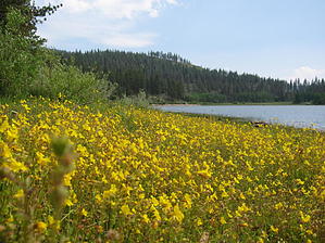
Implement an Adventure by AZLOT69 Acquired by the Nevada State Parks, the small pond was enlarged by constructing an earthen dam. The hike starts from a paved parking lot that has restroom facilities. Nevada State Park day use fee applies. The hike can be done in either direction. Clockwise, the first half of the hike is in the sun and the second half is shaded by forest and vise versa. Many mountain birders frequent the area, which gives you an idea of wildlife present. The hike traverses a meadow into a stand of Aspen and into Pines with several places to stop, sit and observe. Very little change in elevation makes this trail a nice family outing and is quite popular. Signed access to more difficult trails are encountered but route finding is not an issue as you simply keep the lake in view. An occasional placard will inform you of plant and animal life in the area. Near the dam, venture off trail near the water and some large granite boulders. Look for evidence of the Washoe Indians passing this way as they migrated from the valleys to Lake Tahoe on their quest for food. Several mortars and metates can be located. A picnic might be in your incentive to complete the loop as the State Park has tables. A popular option is to rent a backcountry cabin from the Forest Service. Check out the Official Route and Triplogs. Leave No Trace and +Add a Triplog after your hike to support this local community. | |||||||||||||||||||||||||||||||||||||||||||||||||||||||||||||||||||||||||||||||||||||||||||||