Route Editor

| Guide | ♦ | 7 Triplogs | 0 Topics |
details | drive | permit | forecast | route |
stats |
photos | triplogs | topics | location |
| 72 | 7 | 0 |
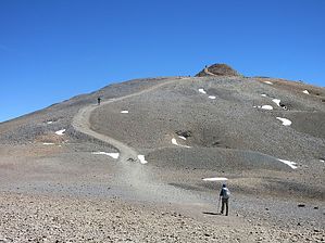
A Theatrical Hike! by DixieFlyer The entirety of this hike is above the treeline. Afternoon thunderstorms can pop up almost without warning during the summer hiking season, so it is best to start this hike early in the morning. Even with an early start, it is wise to check weather forecasts the day you are doing this hike. Overview Mount Lincoln (elevation of 14,286' and prominence of 3,862') is part of the DeCaLiBron Loop that encompasses four 14ers. Mount Lincoln is the highest peak in the loop, and it is the 8th highest 14er in Colorado.
Wilbur F. Stone named Mount Lincoln in 1861 for the newly elected 16th president of the United States, Abraham Lincoln. Hike From the trailhead, follow the trail north for a short distance, and you'll come to a fork. The right fork goes east to Mount Bross, and the left fork continues north up toward Mount Democrat and Mount Cameron. Take the left fork to continue north. The trail is primarily class 1 hiking, although there is a bit of what some might consider class 2 hiking. In any event, it is relatively easy hiking, the high altitude notwithstanding. After hiking for about 1.5-miles, you'll arrive at a saddle at around 13,400'. At the saddle, the trail splits: taking a left and going SW will take you to Mount Democrat, and taking a right and going NE will take you to Mount Cameron. Take a right at the saddle. The trail is a bit steep, but the footing is generally sound, so it is not difficult. After about a mile, you'll reach the summit of Mount Cameron. From there, the trail continues for another half mile or so up to the summit of Mount Lincoln. This section of the trail is about as acceptable as it gets -- it is mostly very wide, it's easy to hike on, and Mount Lincoln is in view the entire way. Once at the summit of Lincoln, you'll enjoy unobstructed, 360-degree views. You'll have a couple of options to get back to the trailhead. One option is to reverse course and go back to the trailhead the way that you came. This is the default route for this guide. The other option is to make a loop out of the hike by going south to Mount Bross on the way back to the trailhead. The second option is the more popular option of the two; many (if not most) people doing this hike will complete the full Decalibron Loop. For details on this loop, check the excellent Decalibron Guide. Check out the Official Route and Triplogs. Note This is a more difficult hike. It would be unwise to attempt this without prior experience hiking. Leave No Trace and +Add a Triplog after your hike to support this local community. | ||||||||||||||||||||||||||||||||||||||||||||||||||||||||||||||||||||||||||||||||||||||||||||||||||||||||||||||||||||||||||||||||||||||||||||||||||||||||