Route Editor

| Guide | ♦ | 8 Triplogs | 0 Topics |
details | drive | no permit | forecast | route |
stats |
photos | triplogs | topics | location |
| 31 | 8 | 0 |
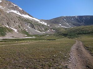
Shortchanged by Topography by rvcarter Mount Cameron is an “unranked” 14er in Colorado because it does not enjoy a topographic prominence of at least 300 feet; its highest point is only 138 feet above its saddle with Mount Lincoln, which is taller and therefore gets the official recognition as one of the famous 53 Colorado 14ers. Cameron is one of five such unranked 14,000-foot peaks in Colorado, the others being El Diente, Conundrum Peak, North Massive, North Eolus, and North Maroon Peak. In reality, at 14,238 feet, Cameron is a danged high 14er, since it is only 195 feet less than Mt. Elbert the tallest in Colorado. It’s considered to be a relatively easy 14er, mainly because of the 12,000-feet trailhead. Cameron is located in the Mosquito Range of the Pike National Forest. Mount Cameron is additionally significant because it is one of the four close-by 14ers known collectively as the Decalibron. Decalibron is an abbreviation derived from the first letters of Democrat, Cameron, Lincoln, and Bross. Many very fit hikers attempt to climb all four peaks in a single day (see https://hikearizona.com/map.php), but it is a full day and needs favorable weather to accomplish. While underappreciated because of the “official 14er” slight, Mount Cameron is a great hike just by itself. Because of their relative ease for climbing (compared with other 14ers), all of the routes to and between these peaks (with the possible exception of Bross from the east) are likely to be crowded on weekends during summer. Hike The most common starting point for attempts to Cameron or the other three is the Kite Lake trailhead (12,000 feet), reached via a 6.5 mile drive on a fairly good dirt road (CR #9) from the small village of Alma which is located between Breckenridge and Fairplay on St. Route # 9. High clearance vehicle recommended but you can make it really close to Kite Lake with a sedan (I saw a Toyota Versa in the parking lot). The parking lot at the trailhead may be full (nominal fee), but there is lots of free parking along the road below. There is a pit toilet at the TH, and a mapboard showing the routes.
After a while the trail gets steeper and rockier. There are a few places where boulder hopping is needed but nothing above class 2. Most of the way is well marked and the trail is easy to follow. The last portion of the trail to the saddle is a series of switchbacks. At the saddle, which is about 13,300 feet, take a break and look north. The valley on that side is beautiful, and on most days you can see Quandary Peak in the distance. When you’re ready, resume hiking to your right (northeast) on a trail which is visible up to the first false summit. Even in July, you may have to dodge several patches of residual snow, but keep plodding up. Eventually you arrive at the summit of Cameron, which is basically a nondescript rounded pile of rocks. Nothing distinctive about the summit, except you can see the three official 14ers (Democrat, Lincoln and Bross) very easily. Cameron is sort of in the middle of the three in terms of the trail system layout to reach the others. The views in every direction are outstanding; especially south to the valley which contains Fairplay, and west to the Collegiate 14ers in the Sawatch Range. It’s hard to miss looking down at Kite Lake, because you can see it for most of the way. Return the same way you went up, or branch off to one or more of the other peaks in the “Decalibron”. Warning: Storms accompanied by lightning, are nearly a daily occurrence in mountainous Colorado. Many hikers are struck by lightning each year. The rule of thumb is to be well off the peak before noon, but you should look at weather forecasts before starting out and watch the sky while on the trail. Alert The trails to Cameron (and the other peaks on Decalibron) are not dog friendly, even though a number of people bring one along. The precarious footing along all routes in the area make an unleashed dog hazardous to hikers who are trying to maintain their balance on boulders and loose rock. Check out the Official Route and Triplogs. Leave No Trace and +Add a Triplog after your hike to support this local community. | |||||||||||||||||||||||||||||||||||||||||||||||||||||||||||||||||||||||||||||||||||||||||||||||||||||||||||||||||||||||||||||||||||||||||||||||||||||||||||||||||||