Route Editor

| Guide | ♦ | 7 Triplogs | 0 Topics |
details | drive | no permit | forecast | route |
stats |
photos | triplogs | topics | location |
| 76 | 7 | 0 |
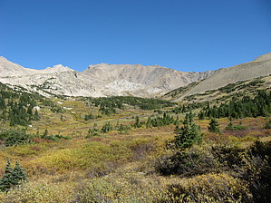
Harvard is hardly Hard by Jim The trail is not named, "Mount Harvard Summit Trail". Instead, from the west side of the trailhead parking area, locate the only trail and hike it west out of the parking lot. There is a kiosk sign, so you can't miss it. The trail drops down and crosses the creek over a well built bridge, and then proceeds up the valley along the creek for about 1 1/2 miles. This section seems to contain the most aspen, and therefore the most amount of leaf color if you came for that purpose. You will then drop down and re-cross the creek over another well built bridge.
Depending on the time of year, you might have a pretty decent wildflower display or a lot of color in the willows of the lower alpine zone. Water is abundant here, with a lot of small crossing. Late in summer, some may be dry, but the larger streams should have flowing water in them. As you progress higher, there is another trail junction with a small sign. Going straight takes you to Bear Lake at roughly 12,400 feet, a nice place to relax or spend the night. Going right takes you up to Harvard itself. From this point on, you have a nice view of the summit, and should have no trouble finding your way, as there are numerous large stone cairns in anyplace the trail isn't super obvious. You'll pass through alpine meadows, a talus field with a well built trail, and then back across another alpine meadow on the south slope of the peak. The alpine vegetation extends so far up the mountain that it confused me as to how high I was. I was well over 14,000 feet yet still thought I was only in the upper 13,000. There is a 13,588 foot peak to the south of Harvard, and once you can see over that, you're almost home. The trail in the last part is steep, but very easy to hike, and when it sort of peters out, you should be just below the summit. In the last 50 to 75 feet, the hike becomes a scramble, class 2, maybe 3 if you look for it, and just enough to be fun. Then, you are on the summit. Some folks will want to traverse to Columbia. Just be sure you have enough daylight and good weather to do that. Otherwise, descend the way you came. I took my time and made this in less than 7 hours of hiking. Check out the Official Route and Triplogs. Leave No Trace and +Add a Triplog after your hike to support this local community. | |||||||||||||||||||||||||||||||||||||||||||||||||||||||||||||||||||||||||||||||||||||||||||||||||