username
X
password
register
for free!
help
  This is likely a great time to hike this trail!  Check out "Preferred" months below, keep in mind this is an estimate.
 

Sawmill Cabin via East Eagle Trail #33, AZ

Guide 2 Triplogs  0 Topics
  5 of 5  
Fav
Wish
2
details
drive
no permit
forecast
map
stats
photos
triplogs
topics
location
83 2 0
Statistics
tap row or icons for details
Difficulty 1 of 5
Distance One Way 5 miles
Trailhead Elevation 5,455 feet
Elevation Gain 500 feet
Kokopelli Seeds 6.67
 Interest Seasonal Creek & Perennial Creek
unreported if dogs are allowed
editedit > ops > dogs to adjust
feature photo
Photos Viewed All MineFollowing
59  2012-08-29 outdoor_lover
24  2012-08-29 SkyIslander18
Author
author avatar Guides 16,843
Routes 17,472
Photos 24
Trips 1 map ( 6 miles )
Age 28 Male Gender
Location HAZ, TrailDEX
Associated Areas
list map done
Alpine Region
Historical Weather
Trailhead Forecast
Expand Map
Preferred Oct, Apr, May, Sep
Sun  5:54am - 6:40pm
0 Route
 
0 Alternative


remove free decal offer

  Likely In-Season!
Guide Needed
Publish Full Detail Guide


Use +Add above to share photos and triplogs
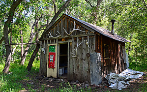
Overview: Sawmill Cabin is this hikes destination and is reached by using the lower western 5 mile section of the East Eagle Trail #33. Expect numerous water crossings through the perennial flowing Eagle Creek along this trail.


    Check out the Triplogs.
    Leave No Trace and +Add a Triplog after your hike to support this local community.

    One-Way Notice
    This hike is listed as One-Way.

    When hiking several trails on a single "hike", log it with a generic name that describes the hike. Then link the trails traveled, check out the example.
    WARNING! Hiking and outdoor related sports can be dangerous. Be responsible and prepare for the trip. Study the area you are entering and plan accordingly. Dress for the current and unexpected weather changes. Take plenty of water. Never go alone. Make an itinerary with your plan(s), route(s), destination(s) and expected return time. Give your itinerary to trusted family and/or friends.

     Permit $$
    None


     Directions
    or
     Road
    High Clearance possible when dry

    To hike
    From Safford - Head east out of town on Highway 70/191 for 10 miles. Turn left onto Highway 191 (Morenci/Clifton) and take for 23.75 miles to the Highway junction known as 3-Way. Turn left and travel north on 191 for approximately 37 miles up through Morenci/Clifton & the Freeport-McMoRan mine along the lower Coronado Trail. Turn left onto Eagle Creek Road (FR 217) and take the 22 mile dirt road to it's end and park at the last site of Honeymoon Campground to the right (just before the gate).
    page created by SkyIslander18 on Sep 02 2012 4:48 pm
     90+° 8am - 6pm kills
    helpcorrectionissue

    end of page marker