This urban trail is one spoke of a variety of trails you can experience from a no fee area of the California State Park system at Tahoe City, California. There is ample parking and restrooms available.
In 1899 The Lake Tahoe Railway and Transportation Company built a sixteen mile railroad between Tahoe City and Truckee, Ca. The railroad operated until World War 2 , when it was ripped up for scrap. The railroad bed was converted to recreation trail. The trail runs along the Truckee River which is the only outlet of water from Lake Tahoe. This is a recreation corridor and the eight plus mile trail offers access to hiking, fishing, bicycling, skating, rafting, kayaking, and picnicking. Several restaurants are available and rafts and bicycles are available to rent.
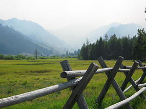
The trail starts at the Lake Tahoe Dam near Fanny Bridge on Highway 89. It is a paved pathway and serves for a variety of needs. In summertime beat the crowds by planning a morning outing. The trail follows the Truckee River northward on the East side of the river. There are mild grades. This is no wilderness experience especially in summer months as the colorful rafts and kayaks pass you on one side and traffic races by on the road above you. At four miles, the commercial rafts are removed at River Ranch which offers viewing and restaurants overlooking the river. The trail continues north to Midway Bridge where you cross the Western States Trail. The trail crosses the highway under this bridge and continues to a stoplight at Squaw Valley. Cross the road to the west where there is a trailhead/commuter parking lot. The trail continues to the west at the south end of this lot. The trail offers respite from the crowds at this point as you have left the river and are skirting the wilderness in mature forest growth. Beautiful meadows lie before you with spectacular mountains surrounding this picturesque valley. The trail continues three more miles and ends at the Squaw Valley Ski Resort, home of the 1960 Winter Olympics. Return the way you came or you can take a bus back to Tahoe City.
When hiking several trails on a single "hike", log it with a generic name that describes the hike. Then link the trails traveled, check out the example.
WARNING! Hiking and outdoor related sports can be dangerous. Be responsible and prepare for the trip. Study the area you are entering and plan accordingly. Dress for the current and unexpected weather changes. Take plenty of water. Never go alone. Make an itinerary with your plan(s), route(s), destination(s) and expected return time. Give your itinerary to trusted family and/or friends.
Permit $$
None
Directions
Road
Paved - Car Okay
To hike From I 80 in Truckee, Ca.: take Highway 89 south 13 miles, to Tahoe City, Ca. At the intersection of SR 28 and SR 89 turn south towards Meeks Bay. Travel 1/4 mile to marked parking area on right. Continue into parking area. No fee. There is also bus service to-from this parking lot.
 Route Editor


