Route Editor

| Guide | ♦ | 8 Triplogs | 0 Topics |
details | drive | no permit | forecast | map |
stats |
photos | triplogs | topics | location |
| 190 | 8 | 0 |
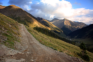
drive-thru history in the San Juans by PrestonSands The Alpine Loop Scenic Byway is a high altitude backroad loop connecting the towns of Silverton, Lake City, and Ouray. Along its approximately 65 mile long route are rivers, lakes, ghost towns, abandoned mines, 14,000 foot peaks and trailheads. Two mountain passes, Engineer and Cinnamon, both above 12,000 feet, are popular destinations for four wheel drive adventures. Due to snow and avalanche danger, summer is the recommended season for this drive. Although primarily known as a 4x4 route, much of the Alpine Loop Scenic Byway is more mild (assuming no snow, that is). Any vehicle can drive between Silverton and Eureka; between Lake City and Capitol City; and between Lake City and Sherman. Above Eureka, Capitol City, and Sherman, high clearance is mandatory, and four wheel drive is highly recommended. The upper Uncompahgre River tangent going past Abrams Mountain is said to be extremely rough.
Silverton Public Lands Office (970) 387-5530. Hours: Seasonally, May 15 thru September 15, 9:30 a.m. to 3:30p.m. every day except closed Wednesdays. Call (970) 884-2512 for off season information. Lake City Chamber Of Commerce (800) 569-1874. Warning Know your vehicle's limitations if you plan to travel the Alpine Loop Scenic Byway. Come prepared with appropriate tires, spare tire(s), extra food and water, warm clothing, etc. Sudden storms are possible. Be cautious of lightning, especially whenever you are above treeline. History The area that the Alpine Loop Scenic Byway travels through is loaded with history! More than enough to fill numerous books, which it has. A bit of historical trivia, though... The route between Silverton and Animas Forks largely follows the route of the Silverton Northern Railroad, a narrow guage mining railroad that existed from the late 1890's to 1942. This railroad was constructed to haul ore from the rich mines along the upper Animas River back down to the waiting trains of the Denver & Rio Grande Railroad at Silverton. Animas Forks, at 11,100 feet, was once the highest town in America. Bitter cold and excessive snow caused most citizens to pack up and leave during the winters. Animas Forks was largely abandoned by the 1920's. Numerous old buildings still stand here, and the BLM has created a brochure-guided walking tour of the historic townsite. A historical marker along Highway 149 between Lake City and Lake San Cristobal (one half mile off route from the Alpine Loop Scenic Byway) marks the site of an 1874 massacre of an ill-fated prospecting party. Party leader Alferd Packer was ultimately caught, tried, and convicted of murder and cannibalism. The ghost town of Capitol City was founded in 1877 with the intention of surpassing Denver and becoming the state's capitol. A few buildings remain. Hiking The Alpine Loop Scenic Byway is used to access many hikes along its route, including the 14ers Handies, Redcloud, Sunshine, Uncompahgre, and Wetterhorn. Water Sources:The Alpine Loop Scenic Byway crosses numerous creeks, most of which have water present. Purification is recommended, though. Camping There are a number of great campsites along the route, and along side roads. Pay attention to public land signage and do not camp on private property. Check out the Triplogs. Leave No Trace and +Add a Triplog after your 4x4 trip to support this local community. | ||||||||||||||||||||||||||||||||||||||||||||||||||||||||||||||||||||||||||