Route Editor

| Guide | ♦ | 11 Triplogs | 0 Topics |
details | drive | permit | forecast | route |
stats |
photos | triplogs | topics | location |
| 111 | 11 | 0 |
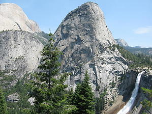
America The Beautiful by AZLOT69  The Nevada Falls Loop will be accomplished by taking the John Muir Trail up to the top of Nevada Falls and return via the Mist trail in a counterclockwise direction. The Nevada Falls are the most remote of the major waterfalls in Yosemite.
This is a decision point, not only for your destination but for the degree of difficulty. The Mist Trail is to your left. The John Muir Trail is to your right. Both trails meet at the top of Nevada Falls. If you simply want to get a closer look at Vernal Falls go left and follow the Mist Trail. If you are attempting to go to Half Dome on a day trip you may be inclined to go left and take the Mist Trail. The reason being is the John Muir Trail is 2 miles further in length to get to Nevada Falls. The trade-off is it is a much gentler incline, although you will lose count of the number of switchbacks. Either way, you have to gain 1650 feet. The paved trail ends at this point and you lose most of the casual hikers. The Mist Trail will ascend 800 feet in the next mile by using 500 granite stairs. We take the John Muir Trail to the right. In a short distance, a trail enters from below on the right. This is marked stock only. This joining trail is where the horse and mule trips come into the picture. The views get better and each time you take a picture and continue on the next switchback the same view gets even better. You are on the north side of the mountains in the deep cover of California Black Oaks, Douglas Fir, and Bigleaf Maples. An occasional opening in the forest will get you a view of Yosemite Falls across the valley. A fall of 2425 feet makes it the 5th tallest waterfall in the world. After several switchbacks and perhaps an encounter with a mule train, you arrive at Clark Point. An open area of brilliant granite. Ahead of you lies Liberty Cap, Mt Broderick, and to the right of it Nevada Falls. A trail junction at this point gives you another choice. This is a connector trail. To the left, you can join the Mist Trail at the top of Vernal Falls and return or as we will, take the John Muir Trail to the right and continue to Nevada Falls. The switchbacks continue along the sheer granite cliffs dripping water which is rather refreshing. Flowers cling to the wet cliffs and the views improve as the foliage thins. At last, you arrive at the falls. A sturdy wooden bridge takes you over the Merced. To the left is a nearly 600-foot drop of Nevada Falls. To the right, you will quite likely see people wading in the water. Caution must be used as strong currents have swept people over the falls almost every year. Railings allow you to look straight down from the top of the falls. The solid granite trembles underfoot from the power of the water in the Merced at this point. The sound of the water is deafening as it reverberates off the surrounding cliffs. Continue along the trail to the next junction where a restroom is located. This junction is the Mist Trail. To complete our loop turn left on the Mist Trail and start your descent. It has many steps and is very steep. Caution and a hiking stick help. An occasional hiker struggles toward you and few can speak. Nevada Falls is roaring on your left and soon you come to a photo opportunity at the base of the falls. The trail levels along the river and soon starts its decline again. The river picks up speed in an area called the Silver Apron. This slick rock granite is commonly used as a slide for an adventurous wet ride into Emerald Pool. Emerald pool is another area common for wading but again caution must be taken as the swift current could sweep you over Vernal Falls which lies just ahead. The trail becomes hard to follow at this point because of all the activity around the water. Follow the river downstream and you come to the head of the falls. Railings allow you to look straight down. To return to the trail, follow the railing to your left. This is your last climb up. The narrow opening ahead is where the staircase down starts. Hand railings come in handy on this first section down the incredibly steep-walled river channel. There is a reason this is called the Mist Trail. As you descend you are going to get wet. The mist from Vernal Falls on your right can cause a good soaking. Be careful of your footing and you may even sport a poncho. Watch for a rainbow, but concentrate on the 500 large steps down you must take to rejoin the John Muir Trail. You are back at the drinking fountain and paved path to return to the trailhead.
Check out the Official Route and Triplogs. Note This is a more difficult hike. It would be unwise to attempt this without prior experience hiking. Leave No Trace and +Add a Triplog after your hike to support this local community. | ||||||||||||||||||||||||||||||||||||||||||||||||||||||||||||||||||||||||||||||||||||||||||||||||||||||||||||||||||||||||||||||||||||||||||||||||||||||||||||||||||||||||||||||||||