username
X
password
register
for free!
help
  This is likely a great time to hike this trail!  Check out "Preferred" months below, keep in mind this is an estimate.
  

Tenaya Canyon, CA

Guide 1 Triplog  0 Topics
  5 of 5  
Fav
Wish
0
details
drive
permit
forecast
map
stats
photos
triplog
topics
location
16 1 0
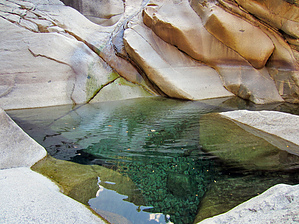
Canyons are inherently risky. Flash floods occur without notice on sunny days. Technical skills & surrounding topography knowledge required yet does not eliminate risk.
Statistics
tap row or icons for details
Distance One Way 10 miles
Trailhead Elevation 8,169 feet
Elevation Gain -4,000 feet
Kokopelli Seeds 16.67
 Interest Off-Trail Hiking, Perennial Waterfall & Perennial Creek
 Dogs not allowed
feature photo
Photos Viewed All MineFollowing
16  2012-09-29 toddak
Author
author avatar Guides 16,843
Routes 17,472
Photos 24
Trips 1 map ( 6 miles )
Age 28 Male Gender
Location HAZ, TrailDEX
Historical Weather
Trailhead Forecast
Expand Map
Preferred Aug, Sep, Oct
Sun  5:31am - 6:21pm
0 Route
 
0 Alternative


remove free decal offer

  Likely In-Season!
Overview: A beautiful forested and pool-filled canyon, hidden deep below the soaring granite walls of Clouds Rest and Mount Watkins. Miles of rock hopping and boulder scrambling, with four rappels up to 70 feet from bolted anchors. Best in late summer and fall, the inner gorge would be impassable at high water levels.


There are two approaches: 1) follow the outlet of Tenaya Lake, descending the steep slabs south of Pywiack Cascade or 2) direct descent from Olmsted Point to the base of Pywiack Cascade via a steep, brushy gully. There are also two exits: 1) climb back up and out via Snow Creek trail or 2) continue down into the Valley and car shuttle back to the start.

2018-07-14 HAZ_Hikebot


    Check out the Triplog.
    Leave No Trace and +Add a Triplog after your canyon trip to support this local community.
    WARNING! Hiking and outdoor related sports can be dangerous. Be responsible and prepare for the trip. Study the area you are entering and plan accordingly. Dress for the current and unexpected weather changes. Take plenty of water. Never go alone. Make an itinerary with your plan(s), route(s), destination(s) and expected return time. Give your itinerary to trusted family and/or friends.

     Permit $$
    NPS

    Yosemite National Park
    Fees & Passes
    Half Dome Permit - Currently required 7 days a week. Check the link for the most up-to-date information.

    2014 - 300 permits issued daily, 225 for dayhikers.
    2013 - 400 permits issued daily, 300 for dayhikers.


     Directions
    or
     Road
    Paved - Car Okay

    To canyon trip
    Start from Sunrise trailhead or Olmsted Point in Yosemite NP
    page created by toddak on Oct 03 2012 6:41 pm
     90+° 8am - 6pm kills
    helpcorrectionissue

    end of page marker