 Route Editor

| Guide | ♦ | 326 Triplogs | 0 Topics |
details | drive | no permit | forecast | route |
stats |
photos | triplogs | topics | location |
| 710 | 326 | 0 |
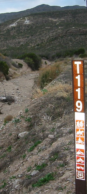
Changing... to stay the Same! by imike  Note: T119 is now marked on the maps incorrectly.
The new trailhead sign for #119 does designate that the route on down to the city is not open to ATV use, but the abuse on the upper portions will likely continue. The sign also says that the trail is open to motorcycle use; interesting in that the lower trailhead sign now designates that "A" trail is no longer open for motor bikes. I guess you can ride down the hill but not up? Trail 119 remains the best hiking route for accessing West Side road from Alamogordo, or visa versa... it passes adjacent to the two highest points: Ortega Peak and Hershberger Peak. It is the only non-canyon route up and down the mountain. It also provides an easy connection to the extended reaches of Mineral Springs Trail and the Ortega/Dry Canyon Traverse, creating looping options for all of the Alamogordo area canyon hikes. Below Ortega Peak, the trail averages over 900' per mile in up/down gradient... this is the trail to enjoy some high quality training, yet it rarely sees much hiking traffic. So... everything changes... and, pretty much stays the same. Check out the Official Route and Triplogs. Leave No Trace and +Add a Triplog after your hike to support this local community. One-Way Notice This hike is listed as One-Way. When hiking several trails on a single "hike", log it with a generic name that describes the hike. Then link the trails traveled, check out the example. | |||||||||||||||||||||||||||||||||||||||||||||||||||||||||||||||||||||||||||||||||||||||||||||||||||||||||||||||||||||||||||||||||||||||||||||||||||||||||||||||||||||||||||||||||||||||||||||||


