The drive to Henry W. Coe State Park is worth the trip alone but when you arrive at this former ranch land high in the Mount Hamilton Mountain Range which separates Silicon Valley from the San Joaquin Valley you will think you are on an operating ranch. All the range buildings have been preserved and frozen in time to 1958 which was when the Coe family donated the land to become the second largest State Park in California. The Coe family worked this land from 1900-1953. At 87,000 acres, hiking, backpacking, camping, fishing and swimming can be enjoyed. With its proximity to the San Francisco area you would think crowds, but you would be wrong. Few locals know about it or use it. Within the park is a 23,340 acre state designated wilderness area, and over 250 miles of hiking trails.
This hike will be a clockwise loop starting from the visitor center headquarters taking the Corral Trail to the Flat Frog Trail to the Middle Ridge Trail to Fish Trail back to the Corral trail and returning to the visitor center. The trails are in excellent condition and well signed. Be sure to pick up a map at the visitor center when you pay the $5.00 day use fee. Restrooms are available.
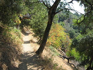
Corral trail is fairly flat and hugs the side of a steep hill and at times hand railings protect you from steep drop offs. There is plenty of shade from the tremendous Oak trees that grow in this area. Although there is not much rainfall here, heavy evening-morning fog from the ocean support a vast forest of some unusual plants. The Valley Oak are believed to be the largest Oak tree in America. They are complimented by the Blue Oak which has much smaller leaves and grows no where else in America. The trail continues to an open area with grassy fields. In summer the golden appearance of these grasses led to names such as golden valley. At the first intersection you have many choices. For our purpose take the Flat Frog Trail, ahead and to the left. This Trail is one of the newest trails in the park. Flat Frog heads north in a fairly flat fashion offering panoramic views of valleys to the east. Manzanittas start appearing along the trail. In this part of California there is a saying that the Manzanita bush thinks it's a tree. These are the largest Manzanittas I have ever seen and later in the hike you will pass thru groves of these trees. At the next intersection take the connector trail to the right signed as to Frog Lake-to Middle Ridge. In a quarter mile you arrive at Frog Lake, a small lake that is stocked with fish. Pause and I'm sure you will pick up the locals concert. Continue on the trail to the right and begin your climb up to Middle Ridge. The next intersection is for Two Oaks Campground. This is a backpackers campground. At this intersection is a water trough catching water from a spring for hikers. A little sign warns to filter the water. Taking the left trail you are now on the Middle Ridge Trail. The trail gets steeper and while gaining elevation you will notice huge Black Oak trees with gigantic clumps of Mistletoe in them. Ponderosa are all around as well as Gray Pine which has needles 8-12 inches long. The Gray Pine also grows no where else in America. Another intersection appears at the top of the ridge. Take the right fork. This is signed Middle Ridge - Poverty Flat Route. Another short gain will then have the trail level out and before long start some fairly steep descents. Plenty of cover makes even a hot day very enjoyable. The next intersection is with Fish Trail. Take this to the right and you start to switchback down to Little Coyote Creek. Manzanitta groves are all around as you hike underneath the canopy of these trees with there colorful trunks. In the Spring, Indian Warriors can be seen near the base of the Manzanitta. Indian Warriors is similar to Missletoe but it grows on the ground attaching itself to Manzanitta roots. It is crimson color in Spring and legend has it they grow where a warrior fell. The trail crosses Little Coyote Creek and then you must regain all that altitude to rejoin Flat Frog at the Junction with the Corral Trail for the return segment.
WARNING! Hiking and outdoor related sports can be dangerous. Be responsible and prepare for the trip. Study the area you are entering and plan accordingly. Dress for the current and unexpected weather changes. Take plenty of water. Never go alone. Make an itinerary with your plan(s), route(s), destination(s) and expected return time. Give your itinerary to trusted family and/or friends.
Permit $$
information is in description
Directions
Road
Paved - Car Okay
To hike Coe Park is in the Inner Coast Ranges east of Morgan Hill, Ca. a town about 15 miles south of San Jose,Ca. on U.S. Highway 101. Highway 101 has three Morgan Hill exits. The middle one, East Dunne Avenue, is the one you take to get to the park. Heading south on 101, take the exit, turn left at the stop light, and cross over 101. Heading north on 101, take the exit and turn right. The road goes thru a residential area for three miles then climbs a hill. At the top of the hill you have about 10 more miles of paved narrow, winding, scenic mountain road ahead. The road ends at the park.
You'll be heading east and climbing into the hills through residential areas for the first three miles. At the top of the first ridge of hills, when you come to a Y in the road, look for a sign that says "Henry W. Coe State Park, 10 miles." You'll bear right at the Y.
 Route Editor