 Route Editor

| Guide | ♦ | 5 Triplogs | 1 Topic |
details | drive | permit | forecast | map |
stats |
photos | triplogs | topic | location |
| 127 | 5 | 1 |
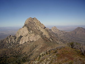
Need a Longer Day! by imike  While there is an official Fillmore Canyon Trail, really that one should more correctly be named the Modoc Mine Trail. It winds up to the ruins of the Historic Mill and Mine area, then winds for a short distance through an interesting gorge just past the mine site. The gorge is part of the lower drainage that flows out of Fillmore Canyon and a couple of other drainages. That trail terminates around the 5600' level... you drop down and into Fillmore Canyon up around the 6100' level.
Turn right and begin enjoying the trailed portion of Fillmore Canyon. You will hike the ridge to the south of the canyon then across a drainage, dropping down and around into the canyon proper. At this point the towering cliffs begin to define the hike. The trail wanders the side ridge then drops down into the canyon bottom. At times it is in the wash, at times on one side of the bench or the other. This pattern will continue up to the Narrows. Needle Peak and the towering ridges of the Needles flank you to the north... exceptional rock formations over shadow you on the south side. This is a great section of hike... The Narrows: On the topo map this feature suggests a dramatic section... while an interesting area, it is not quite the slotted detail area you might imagine. As like most of Fillmore Canyon, it is a bit overgrown. The rock is exceptional... for many, the hiking day ends here, and if this is your turn around point you will have had a great day. Above the Narrows you may or may not find the faint trail that winds in and out of the canyon bottom. A fire devastated the area some years ago and the resultant undergrowth response has been impressive. If there have been no hikers to knock down the growth, it can be hard to see the use trail. Basically, stay near the bottom and bear to the left. You would likely be headed for one of two routes: up and over the saddle towards Indian Hollow on the east side of the mountain... or, up towards Organ Peak. The drainage or ridge approach to the saddle is more obvious. You turn left and hike up the first drainage past the prominent rock spires of Needle Peak. (not immediately next to the cliffs, but the wider cut just over to the east). The turn is usually marked with a variety of rock cairns. The route to Organ Peak is a whole other story. Folks have hiked all the ridges and cuts to make their way up... basically, if you just keep climbing you will get there. If you would like to take the easiest route, I suggest looking out for a bedrock formation that blocks the canyon bottom... it is just a few feet tall, but it stands out among all the overgrown jumble. What you want to do at that point is climb the ridge immediately to your right and stay approximately on the top of that ridge all the way up to the Observatory. It is steep, but not too overgrown. Watch for broken limbs to nail the best path. You will eventually crest the ridge... walking up to the ruins of an old storage shed with the abandoned Observatory up the hill to your left. At the Observatory you will be standing at 8564'. If you would like to score Organ Peak at around 8850, you will need to follow the ridge south (take off from behind the storage shed) bushwhacking your way up and to the top. It looks to be a long way away, but you should take less than an hour to hike that final bit... ...or, hang out at the Observatory taking in the impressive views... gaze down at the real Fillmore Canyon trail... or over to the east side: Baylor Canyon, Indian Hollow, White Sands. It is all nice! This is not a hike for beginners... and it will challenge experienced, conditioned hikers. If you choose a less than optimal route, you will face thick overgrowth, including a variety of prickly, thorny bushes. Go prepared and have a great adventurous day. There is a per car fee. Annual Permit holders get a discount. This is on BLM land... no pets allowed on trails. Hike from either the Visitor center or the picnic grounds. This is a good one. Check out the Triplogs. Note This is a more difficult hike. It would be unwise to attempt this without prior experience hiking. Leave No Trace and +Add a Triplog after your hike to support this local community. One-Way Notice This hike is listed as One-Way. When hiking several trails on a single "hike", log it with a generic name that describes the hike. Then link the trails traveled, check out the example. | ||||||||||||||||||||||||||||||||||||||||||||||||||||||||||||||||||||||||||||||||||||||


