username
X
password
register
for free!
help
 
  🔥

McFadden Peak via Park McFadden Trail #55, AZ

Guide 13 Triplogs  0 Topics
  3.3 of 5  
Fav
Wish
1
details
drive
no permit
forecast
🔥
route  
stats
photos
triplogs
topics
location
217 13 0
Statistics
tap row or icons for details
Difficulty 4 of 5
Distance Round Trip 11.2 miles
Trailhead Elevation 5,173 feet
Elevation Gain 1,885 feet
Accumulated Gain 2,361 feet
Kokopelli Seeds 23.01
 Interest Historic, Seasonal Creek & Peak
 Dogs not allowed
feature photo
Photos Viewed All MineFollowing
Will recalculate on button tap!
9  2018-10-10 Jim
20  2016-08-24
McFaddening
mazatzal
12  2015-09-19
McFadden Super Loop
joebartels
19  2015-09-19
McFadden Super Loop
BiFrost
24  2015-09-05
McFadden Loop
hikerdw
19  2015-05-02
FR2752 McFadden Peak Loop
CannondaleKid
15  2013-06-09 DarthStiller
6  2012-04-10
Salome Creek - Upper Loop
toddak
Page 1,  2
Author
author avatar Guides 16,843
Routes 17,472
Photos 24
Trips 1 map ( 6 miles )
Age 28 Male Gender
Location HAZ, TrailDEX
Associated Areas
list map done
Globe Region
Historical Weather
Trailhead Forecast
Radar Map
Expand Map
Preferred Apr, Oct, May, Mar
Sun  6:00am - 6:44pm
Official Route & 1 Rt
 
2 Alternative
 
Historic Fire Perimeteracres
🔥 2016 Juniper Fire30.6k


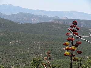
offering excellent views
by HAZ_Hikebot

 
Overview
Here is a scenic and easy to follow trail with quick TH access, located in-between the east boundary of the Salome Wilderness and the Sierra Ancha Wilderness' west boundary. It makes it way up to McFadden Peak, with a 360 view of the surrounding areas. At the peak, McFadden Peak Lookout is an active fire tower. It was built in 1968 and is listed in the AZ historical record.


Interest includes seasonal creeks, a "huge blackberry patch" along the right side of the trail bordering seasonal McFadden Creek(only ~0.25-miles in from the Circle Ranch TH), and a private ranch along the way. This trail and hike is a great way to spend a summer or autumn day between 5250' and a high point of 7135'.
remove free decal offer
2020-10-12
Revised from a single sentence.

2018-07-14 HAZ_Hikebot


    Check out the Official Route and Triplogs.

    Note
    This is a moderately difficult hike.
    Leave No Trace and +Add a Triplog after your hike to support this local community.
    WARNING! Hiking and outdoor related sports can be dangerous. Be responsible and prepare for the trip. Study the area you are entering and plan accordingly. Dress for the current and unexpected weather changes. Take plenty of water. Never go alone. Make an itinerary with your plan(s), route(s), destination(s) and expected return time. Give your itinerary to trusted family and/or friends.

     Permit $$
    None


     Directions
    or
     Road
    FR / Jeep Road - Car possible when dry

    To hike
    From Phoenix: Take Hwy 60E to Globe; In Globe, turn Left on Hwy 188/88; Continue on 188/88 to the intersection of Young Hwy 288; Turn Right on 288 and continue for approx 26+ miles "past" MP286.4 intersection at Reynolds Creek Rd FR410; Continue approx .5mls further up Hwy 288 and look for the Circle Ranch TH sign on the Right side of Hwy 288; Turn Left here on signed but easy to miss unmaintained dirt road FR3781; The Circle Ranch TH parking is approx .25mls further down this FR3781 at the beginning start of signed McFadden Park TR#55;
    page created by Grasshopper on Jul 18 2008 7:01 pm
     90+° 8am - 6pm kills
    helpcorrectionissue

    end of page marker