|
tap row or icons for details
|
| Difficulty |
|
0.5 of 5 |
| Distance Round Trip |
|
7.5 miles |
| Trailhead Elevation |
|
138 feet |
| Elevation Gain |
|
180 feet |
| Kokopelli Seeds |
|
8.4 |
| Interest Historic | | Dogs not allowed |
| | |
|
|
208 |
2015-08-23 |
Big Sur Coastline CA Redux - August 2015 |
Randal_Schulhaus |
|
|
|
12 |
2012-11-04 | Oregon_Hiker |
|
| |
|
|
list |
map |
done |
Central Coast Region |
| | |
|
| |
|
|
Historical Weather |
| Trailhead Forecast | | |
|
 |
|
|
| Preferred Apr, Jun, Jul, Feb |
|
|
| | |
| |
Named Locations Coordinate Links
| |
|
| Point Buchon Trail
|
7.46 mi
632 ft |
|
|
| | |
| |
|
|
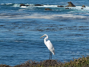
 Overview: Overview: The Point Buchon Trail is accessed from Pecho Valley Road through Montana de Oro State Park south of Moro Bay. The trail follows the Pacific ocean shoreline for approximately 3.5 miles along the top of the bluffs overlooking the ocean. The trail is on PG&E property and provides views of the Diablo Canyon nuclear power plant as well as spectacular ocean views. All visitors are required to sign the Point Buchon Trail waiver form at the entrance gate and may be subject to a security check.
Gate Policy: If a gate is closed upon arrival, leave it closed after you go through. If it is open, leave it open. Leaving a closed gate open may put cattle in danger. Closing an open gate may cut them off from water. Please be respectful, leave gates as found. The exception is signage on the gate directing you otherwise.
|
 Route Editor