Route Editor

| Guide | ♦ | 4 Triplogs | 0 Topics |
details | drive | no permit | forecast | route |
stats |
photos | triplogs | topics | location |
| 38 | 4 | 0 |
Canyons are inherently risky. Flash floods occur without notice on sunny days. Technical skills & surrounding topography knowledge required yet does not eliminate risk.
Trail 2094!! ??? by imike  The Forest Service seems to believe so, too... they numbered it and posted a Carbonite sign to clearly designate it for hikers, bikers, horses and motorcycle riders. Of course the sign only served to give the locals yet another target for the assortment of fire power they love to discharge up in these hills. The surrounding land over which everyone has to approach is BLM. Working with the Forest Service they have tried to limit the abuses, controlling both the rampant ATV abuses... and the over zealous target practice. To date their efforts have resulted in the locals using their ATV's to access the areas to shoot up all the restrictive signs. So much for the idea to convert the area over to hiking and camping.
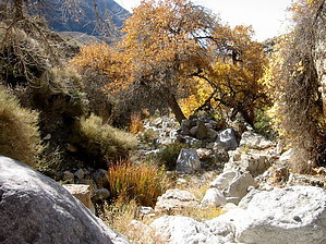
The fun begins as limestone slabs begin to project and protrude up through the canyon floor... finally, they form complete obstacles... oddly sculptured waterfall scapes bridging the canyon bottom. If you look to your right, you will note that the lower sidewalls are angling up with a myriad of layers, thinly stacked and eroding away in very interesting forms. This "stacked layers" section forms the bridge between the lower section and the upper section with it's jumble of giant boulders. The layers fall away a bit over 2 miles into the canyon, just below the Fork into San Andreas South. At this point the route finding and bouldering begins. If you are hiking in the winter months, chances are you will not get to enjoy any sunshine until you clear the layers. There will be some open walking, but not a great deal. The next mile up to Cottonwood Springs can be an interesting challenge. Winding back and forth, side to side, the mileage might well be double the linear distance. Take your time and enjoy. As you work your way up you will have a clear view of the giant waterfall that caps out the lower San Andreas South Canyon. If the boulders pose too great of a challenge... look around, there are always alternative scrambles to avoid the climbs. At a bit over 3 miles into the hike you will find Cottonwood Springs a delight. Huge Cottonwoods clustered amid giant boulders... cattails and grasses... it is a welcome break. The final mile continues with ever more climbing and winding... there appear to be a number of side canyon options for exploring. The canyon finally terminates in a shear cliff... the narrow waterfall pour over is the end of the Lower Upper San Andreas Canyon... another great off trail hike. Do that hike from West Side Road and rap down the falls to connect with this hike? The turn around and down yields equally great views and vistas, especially as the shadows accent the canyon over the course of the day. Take your time and check out the old rusted water feed lines... listen carefully, you will hear rushing water; those old pipes are still in use! This is a great canyon, but demanding. There is no easy loop up and out; you have to downclimb everything you went up... be aware of the time and give yourself plenty of daylight to get out, or take enough gear to enjoy an overnight stay! Check out the Official Route and Triplogs. Leave No Trace and +Add a Triplog after your canyon trip to support this local community. | |||||||||||||||||||||||||||||||||||||||||||||||||||||||||||||||||||||||||||||||||||||||||||||