Route Editor

| Guide | ♦ | 5 Triplogs | 0 Topics |
details | drive | permit | forecast | route |
stats |
photos | triplogs | topics | location |
| 24 | 5 | 0 |
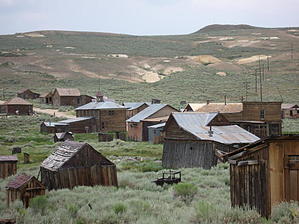
Be a Ghost Buster by AZLOT69 After paying an entrance fee continue to the main parking lot where restrooms are available. There is drinking water but no other amenities. Bring your own food. It is family-friendly and they will make exceptions for the handicapped by letting you drive to the museum in town. Start your hike by paying your respects on boothill. At the entrance to the cemetery, you can pick up a brochure that tells stories about many of the deceased. Being high above the town at this point gives a nice perspective. Hiking south from the cemetery brings you down to Bodie Creek entering town from the west. Follow the creek east. The town is so intact looking that it seems to be a Hollywood set. As you look in the buildings, it's as if the inhabitants just walked away, leaving the shelves stocked and the dinner tables set. As amazing as it is only about 5 percent of the structures remain. One of the first buildings you encounter is the museum. It is staffed and packed with antiques. After the museum head south and up the hill south of town. Dwellings are scattered all the way to the top and beyond but the area beyond the top is fenced off as unsafe. Mine tailings are all around. Head for the mill site to your east. The huge mill structure is intact and as the wind blows you hear the metal siding and roof clang and bang. Structures are leaning every which way and many do not appear to have been very level when they were hastily erected. Follow the entry prohibited fence east as you observe what is left of huge stone structures. Go beyond Bodie creek to the east to see a few old wells and mines. Now head towards the center of town and the red light district. The old jail is here along with the city livery stable and the first bank in these parts. Continue your hike by cruising the deserted streets and imagine the violence and wild living that took place here. Check out the Official Route and Triplogs. Leave No Trace and +Add a Triplog after your hike to support this local community. | |||||||||||||||||||||||||||||||||||||||||||||||||||||||||||||||||||||||||||||||||||||