|
tap row or icons for details
|
| Difficulty |
|
2.5 of 5 |
| Route Finding |
|
1 of 5 |
| Distance Loop |
|
2.5 miles |
| Trailhead Elevation |
|
1,028 feet |
| Elevation Gain |
|
250 feet |
| Avg Time Round Trip |
|
2 hours |
| Kokopelli Seeds |
|
3.75 |
| Interest Historic, Perennial Waterfall & Perennial Creek | | Backpack Yes | |
| | |
|
|
13 |
2008-07-23 | tyrone anderson |
|
| |
|
|
|
list |
map |
done |
Central Region |
| | |
|
| |
|
|
Historical Weather |
| Trailhead Forecast | | |
|
 |
|
|
| Preferred Sep, May, Jun, Aug → 8 AM |
|
|
|
Seasons Spring to Early Autumn |
|
|
| | |
| |
Named Locations Coordinate Links
| |
|
| help future hikers |
| post a gps route now |
| | |
| |
|
|
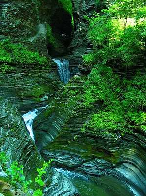
 Stony Brook State Park's terrain comprises hilly woodlands, a deep gorge with rugged cliffs overlooking three waterfalls and fascinating rock formations. 125 tent and trailer campsites are scattered in the woodlands above the gorge in the upper or south end of the park. Visitors can hike rim, gorge or nature trails, play tennis on park courts, picnic or swim in the park's stream-fed pool. In winter, three miles of cross-country trails are available for skiers. Some winter hiking is allowed, but not on the gorge trails. There is only one dumping station available at Stony Brook State Park.Seasons/Hours: Open year round. Camping seasons runs from the first weekend in May to mid-October. All gorge trails close the Friday before Thanksgiving. Bow hunting for deer is permitted during season. Pets: Household pets only; caged or on a leash not more than 6 feet. Proof of rabies inoculation. Not allowed in bathing areas. |
 Route Editor