Overview
Superstition Peak 5057 via Hiero is one of the rare opportunities to hike to a location where you can look down on Weaver's Needle.
Hike
This track shows a one-way route up to peak 5057 paste the Hieroglyphics. The route indicates following the creek bottom for the first part past the hieroglyphics, but a person might find easier going by staying higher on the right on a fairly well-traveled path. Often there is more than one trail, but the tendency seems to be to keep out of the creek bottom, where brush makes travel more difficult. You might find small pools of water at various points along the creek bottom. An abundance of cairns mark critical points along the trail. We discovered that hiking was often in the shade until reaching the ridge. The hike has magnificent views all along the route, and when reaching the first ridge at the saddle at the top, a person might be tempted to stop here. By continuing to peak 5057, the views do become even more magnificent.
During the hike, you will encounter spots where you wonder if you can climb the barrier in the way. All obstacles are relatively easily negotiated if you look closely at the handholds and the places for sound footing. Rather than being technically challenging, the hike is more a matter of conditioning. For the last mile before making the Ridgeline Trail, the grade is 28%, so there is lots of uphill to test your legs.
When hiking several trails on a single "hike", log it with a generic name that describes the hike. Then link the trails traveled, check out the example.
WARNING! Hiking and outdoor related sports can be dangerous. Be responsible and prepare for the trip. Study the area you are entering and plan accordingly. Dress for the current and unexpected weather changes. Take plenty of water. Never go alone. Make an itinerary with your plan(s), route(s), destination(s) and expected return time. Give your itinerary to trusted family and/or friends.
Permit $$
None
Directions
Road
Paved - Car Okay
To Hieroglyphics Trailhead From the East Valley follow US 60 East to South Kings Ranch Road. Kings Ranch Road is 14.1 miles east of Power Road for reference. Turn North on Kings Ranch Rd and follow to 2.8 miles to Baseline. Turn East on Baseline and follow 0.2 miles to Mohican. Turn North onto Mohican and follow 0.4 miles to Valleyview Road. Turn West onto Valleyview and follow (naturally turns North, and turns into Whitetail Road) for 1.4 miles. At the intersection of Whitetail Rd. and Cloudview Road turn East and follow 0.4 miles to the end. The trailhead parking is here and the trail is easy to spot to the East. If the parking lot is full, please do not park illegally or on private property!
From PHX (I-10 & AZ-51) 42.9 mi - about 54 mins From TUC (Jct 1-10 & Grant) 95.3 mi - about 2 hours 3 mins From FLG (Jct I-17 & I-40) 187 mi - about 2 hours 58 mins
 Route Editor

 Overview
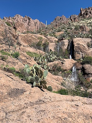


