Route Editor

| Guide | ♦ | 29 Triplogs | 0 Topics |
details | drive | no permit | forecast | route |
stats |
photos | triplogs | topics | location |
| 38 | 29 | 0 |
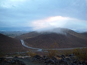
Convenient Cardio by Barrett  History HistoryThe Thunderbird Recreation Area located along Pinnacle Peak west of 55th Avenue is named after a WWII Fighter training facility that used to be located 4 miles south of the park. Its trails wander up and around the Hedgepeth Hills, named for the Hedgepeth ranch that used to be at the site. Access The H4 loop trailhead is reached by following Pinnacle Peak west past 55th Avenue, where it climbs through a pass before heading south and becoming 59th Avenue. The park entrance is on the west side, leading to a paved loop and several paved spurs. Several concrete ramadas, picnic tables, plenty of shade, and a bathroom with drinking fountains outside make for a nice place to relax with views of the surrounding hills. A sandy, shady wash passes through the park from north to south, and small wildlife is abundant. Creosote, Palo Verde, and Brittlebush make up most of the flora, with a scattering of Saguaro. On prime hiking days you may have difficulty finding a parking spot, so off days and times are your friend.
The H4 Loop is a favorite of mine due to its relatively smooth path that allows trail running, and has several ups and downs that provide an efficient interval workout. Parking at the north end of the Amphitheater, follow the trail up the wide access gravel road that skirts the amphitheater itself, then continue to the right, gaining altitude and circling the peak in a counter-clockwise direction. After about 6 minutes you will reach a spur on your right that leads out to a scenic view bench. Continue a few more feet and another spur on your right will lead down to a parking lot that you can originate from if you want a shorter hike. Continue on the main trail as it veers left toward a saddle on the west side of the peak. At this point, you will see a large, low building with a metal roof that you cannot see from below. This is a water storage building, working on the same principle as a water tower. At about the 9-minute mark you will reach the junction of H4 continuing to the left, or H4b on the right. Hang a left and work your way up the switchbacks on your way to the top. Just below the summit you will reach a spur making a beeline to the top, or stay left and work your way around on a more gentle slope. Either way, you'll find a nice, open summit at minute 15 with flat areas and rocks for taking a moment. About 20 yards down the mellow trail on the east side of the peak is a great angled stone and seat that gets some shade in the late afternoon, and commands a great view of most of the park. Heading back down to the saddle, at minute 19 or so take H4b west along the soft ridge to the small summits southwest of "1682", and then down a set of switchbacks at the southern border of the park. H4b ends here, and you will turn left around minute 25 and head east along H1. After crossing a small wash, you'll hop on one more set of switchbacks before circling the mountain completely, and dropping down to the H1 trailhead. Your car and the H4 trailhead are to the left, north of you on the paved park road. 40 minutes total time depending on your pace. Of the three main loops in the park, this is shorter and with less elevation change but makes up for it in the scenic nature of the trail and cool summit. Check out the Official Route and Triplogs. Leave No Trace and +Add a Triplog after your hike to support this local community. | ||||||||||||||||||||||||||||||||||||||||||||||||||||||||||||||||||||||||||||||||||||||||||||||||||||||||||||||||||||||||||||||||||||||||||||||||||||||||||||||||||||||||||||||||||||||||||