username
X
password
register
for free!
help
 
  🔥

Tortilla TH to Tortilla Well, AZ

Guide 38 Triplogs  0 Topics
  2.4 of 5  
Fav
Wish
2
details
drive
no permit
forecast
🔥
route  
stats
photos
triplogs
topics
location
270 38 0
HAZ reminds you to respect the ruins. Please read the Archaeological Resources Protection Act of 1979 & Ruins Etiquette
Statistics
tap row or icons for details
Distance Round Trip 7 miles
Trailhead Elevation 2,922 feet
Elevation Gain 287 feet
Accumulated Gain 677 feet
Kokopelli Seeds 10.39
 Interest Ruins, Historic & Seasonal Creek
feature photo
Photos Viewed All MineFollowing
Inaugural Calculation on Button Tap!
44  2025-04-19
Tortilla Mountain - Superstition Wilderness
chumley
45  2025-04-19
Tortilla Mountain - Superstition Wilderness
John10s
1  2024-03-01
Boulder Canyon TH to Tortilla TH
pseudalpine
4  2024-02-16
Peak 4143 and LDM Jr
pseudalpine
5  2024-02-04
Fish Taco with Bacon
pseudalpine
13  2023-12-21
Tortilla Mountain - Superstition Wilderness
DixieFlyer
36  2023-12-02
Tortilla - Fish Mesa
John10s
8  2023-11-15
Black Cross Fishiness
pseudalpine
Page 1,  2,  3,  4,  5
Author
author avatar Guides 16,843
Routes 17,472
Photos 24
Trips 1 map ( 6 miles )
Age 28 Male Gender
Location HAZ, TrailDEX
Associated Areas
list map done
Phoenix Region
Historical Weather
Trailhead Forecast
Radar Map
Expand Map
Preferred Mar, Nov, Feb, Jan
Sun  6:02am - 6:46pm
Official Route & 4 Rts
 
15 Alternative
 
Historic Fire Perimetersacres
🔥 2019 Woodbury Fire123.8k
🔥 2011 Tortilla Fire10.5 mi*
🔥 View (All) - over Official Route 🔥
*perimeter length in miles


remove free decal offer

 
Guide Needed
Publish Full Detail Guide


Use +Add above to share photos and triplogs
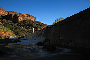
Overview: This is an out and back from the Tortilla Trailhead to the Tortilla Well and returning the same way via FR213


    Check out the Official Route and Triplogs.
    Leave No Trace and +Add a Triplog after your hike to support this local community.
    WARNING! Hiking and outdoor related sports can be dangerous. Be responsible and prepare for the trip. Study the area you are entering and plan accordingly. Dress for the current and unexpected weather changes. Take plenty of water. Never go alone. Make an itinerary with your plan(s), route(s), destination(s) and expected return time. Give your itinerary to trusted family and/or friends.

     Permit $$
    no fees or permits reported

    if incorrect tell us about it


     Directions
    or
     Road
    Strictly 4x4

    To Tortilla Trailhead
    From the junction of Idaho Road & SR-88, follow SR-88 23.0 miles east to FR-213.

    If you do not have 4x4, you will need to park here and hike 3.4 miles to the trailhead. Otherwise, drive in. The first 0.25-mile section is the most difficult.

    The trailhead is not well defined. If you are hiking out on Peter's Trail #105, steer right(west) at the end to the old windmill and water tower. If you are hiking out on JF Trail #106 or Hoolie Bacon Trail #111, continue straight/right to the fence. JF Trail #106 takes off immediately. Hoolie #111 is 0.8 miles off of #106.

    From PHX (I-10 & AZ-51) 60.7 mi - about 1 hour 50 mins
    From TUC (Jct 1-10 & Grant) 154 mi - about 3 hours
    From FLG (Jct I-17 & I-40) 205 mi - about 4 hours
    page created by TheNaviG8R on Dec 16 2012 7:43 pm
     90+° 8am - 6pm kills
    helpcorrectionissue

    end of page marker