|
tap row or icons for details
|
| Difficulty |
|
1 of 5 |
| Route Finding |
|
2 of 5 |
| Distance One Way |
|
1.1 miles |
| Trailhead Elevation |
|
7,241 feet |
| Elevation Gain |
|
101 feet |
| Accumulated Gain |
|
145 feet |
| Avg Time One Way |
|
One Hour |
| Kokopelli Seeds |
|
1.58 |
| Interest Off-Trail Hiking & Peak | | Backpack Possible & Connecting | |
| | |
|
|
5 |
2013-05-12 |
|
|
|
89 |
2013-05-12 |
|
|
|
5 |
2012-11-25 | imike |
|
| |
|
|
|
list |
map |
done |
Southeast Region |
| | |
|
| |
|
|
Historical Weather |
| Trailhead Forecast | | |
|
 |
|
|
| Preferred Oct, Apr, May, Sep |
|
|
|
Seasons Early Spring to Early Winter |
|
|
| | |
| |
Named Locations Coordinate Links
| |
|
| help future hikers |
| post a gps route now |
| | |
| |
|
|
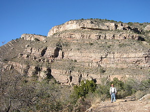
  Stark Peak is mentioned in the official local hiking guide: stands out as the high point above the Forest Trails cutting through Caballero Canyon and Alamo Canyon below West Side Road (FR 90). In fact, from either of those trails you are more than likely going to think the crested high point further west of Stark is the peak. It is not... being a couple hundred feet shorter than the Stark standing not too proud itself at 7342'. From West Side Road the peak can be noted, but it does not really stand out... the prominence from that side is only a bit over 100'. Still, it is a named peak... might as well check it out. The trek up is easy. An old jeep track winds away to the west from the upper Caballero trailhead (T103). There are a number of paths cut around but angle west and a bit south, and move slowly upward and around. You'll move on up the peninsula formation towards the peak. You do not have to stay with the old track; the walking is fairly open over the entire top of the mountain. You do get to enjoy some stunted pine and firs growths for a bit of summer shade. If you access from the north or south, off of either of the official canyon trails, you will enjoy a bit more of a climb. For a more dramatic bit of hiking, follow the ridge down and around to the west from the peak and out to the false peak... the top there is open and cliffed out.
This peak is not worth the drive, but if you are already in the area, might as well check it out! One-Way NoticeThis hike is listed as One-Way. When hiking several trails on a single "hike", log it with a generic name that describes the hike. Then link the trails traveled, check out the example. |
 Route Editor


