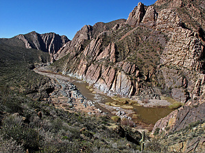
Overview: Remote off trail hiking, with downloaded "Official GPS Route" with waypoints recommended to a "very" scenic ending location at the Salt River.
WARNING! Hiking and outdoor related sports can be dangerous. Be responsible and prepare for the trip. Study the area you are entering and plan accordingly. Dress for the current and unexpected weather changes. Take plenty of water. Never go alone. Make an itinerary with your plan(s), route(s), destination(s) and expected return time. Give your itinerary to trusted family and/or friends.
Permit $$
None
Directions
Road
Strictly 4x4
To hike From the Phoenix area: 60E to east Globe,AZ, then 60N to intersection of 60N/FR303(Haystack Butte Road), then FR303 to intersection of FR303/FR645, then FR645 to intersection of FR645/FR346, then FR346 to TH Park/Hike Start at waypoint coordinates 33.680106, -110.735582
Note: With exception of FR346 (partial high clearance & partial 4WD)all other FRs noted are high clearance "ok" when dry; Posted GPS Routes include "key" driving WPs from the intersection of Hwy 60/FR303(Haystack Butte Road);
page created by Grasshopper on Dec 18 2012 6:23 pm
 Route Editor

 Overview: Remote off trail hiking, with downloaded "Official GPS Route" with waypoints recommended to a "very" scenic ending location at the Salt River.