 Route Editor

| Guide | ♦ | 1 Triplog | 0 Topics |
details | drive | no permit | forecast | map |
stats |
photos | triplog | topics | location |
| 25 | 1 | 0 |
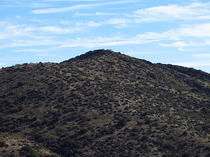
 Peak 4008 is located in the Picketpost Mountain Quadrangle in Pinal County, just west above FR650. With a rise of 468' and an elevation of 4088', it ranks #4201 for the state of Arizona. Its summit coords are: 33.3508 -111.1445. From the FR650-2374 TH, it's just a steep climb up a rocky seldom-used Forest Road until you reach the upper TH. From that point, it's a pretty easy walk up a beaten path to the summit. Peak 4008 is located in the Picketpost Mountain Quadrangle in Pinal County, just west above FR650. With a rise of 468' and an elevation of 4088', it ranks #4201 for the state of Arizona. Its summit coords are: 33.3508 -111.1445. From the FR650-2374 TH, it's just a steep climb up a rocky seldom-used Forest Road until you reach the upper TH. From that point, it's a pretty easy walk up a beaten path to the summit.Check out the Triplog. Leave No Trace and +Add a Triplog after your hike to support this local community. One-Way Notice This hike is listed as One-Way. When hiking several trails on a single "hike", log it with a generic name that describes the hike. Then link the trails traveled, check out the example. | |||||||||||||||||||||||||||||||||||||||||||||||||||||||||||||||||||||||||||||


