Route Editor

| Guide | ♦ | 26 Triplogs | 0 Topics |
details | drive | no permit | forecast | 🔥 route |
stats |
photos | triplogs | topics | location |
| 377 | 26 | 0 |
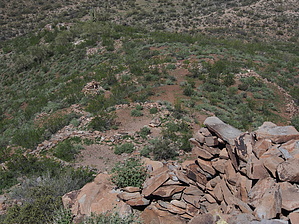
Boring hike bang finish by cabel  This hike will fool you. Park and go through the gate and enter a cholla forest. You turn right and follow a very boring jeep road. If you see anyone on this hike it will be people on ATVs or people out shooting. It is easy to see that this area is used a lot when dove season is in. This hike will fool you. Park and go through the gate and enter a cholla forest. You turn right and follow a very boring jeep road. If you see anyone on this hike it will be people on ATVs or people out shooting. It is easy to see that this area is used a lot when dove season is in.The butte you want is the pointy one ahead on your left. Just keep going knowing that in about four miles you have a surprise waiting for you. Keeping the small pointy butte on your left you will circle it and see the jeep road finish with a very steep incline to the summit of a lesser hill on the east side of the butte. From this point, you will be looking at the north side of the butte and be able to see ruins at the top and down the north side spine. There is a small trail that will take you up about 500 feet for the last 0.5 miles. You will start to see walls everywhere. Research on this site said that the top is defensive and that the site had about 70 pueblos. I went down the south side which is very steep and not recommended but there was a ton of pottery all along the way down. Some of the pieces were very large. The views from the top are worth the trip. Looking to the east is beautiful open land and New River Mesa. Gate Policy: If a gate is closed upon arrival, leave it closed after you go through. If it is open, leave it open. Leaving a closed gate open may put cattle in danger. Closing an open gate may cut them off from water. Please be respectful, leave gates as found. The exception is signage on the gate directing you otherwise. Check out the Official Route and Triplogs. Leave No Trace and +Add a Triplog after your hike to support this local community. | ||||||||||||||||||||||||||||||||||||||||||||||||||||||||||||||||||||||||||||||||||||||||||||||||||||||||||||||||||||||||||||||||||||||||||||||||||||||||||||||||||||||||||||||||||||||||||||||||||||