 Route Editor

| Guide | ♦ | 4 Triplogs | 0 Topics |
details | drive | no permit | forecast | map |
stats |
photos | triplogs | topics | location |
| 99 | 4 | 0 |
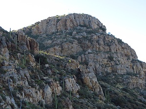
 Overview: Peak 4053 is located in the Teapot Mountain Quadrangle in Pinal County. With a rise of 393' and an elevation of 4053' it ranks #4165 for the state of Arizona. Its summit coords are: 33.1902 -111.0755 Overview: Peak 4053 is located in the Teapot Mountain Quadrangle in Pinal County. With a rise of 393' and an elevation of 4053' it ranks #4165 for the state of Arizona. Its summit coords are: 33.1902 -111.0755Check out the Triplogs. Leave No Trace and +Add a Triplog after your hike to support this local community. One-Way Notice This hike is listed as One-Way. When hiking several trails on a single "hike", log it with a generic name that describes the hike. Then link the trails traveled, check out the example. | ||||||||||||||||||||||||||||||||||||||||||||||||||||||||||||||||||||||||||||


