 Route Editor

| Guide | ♦ | 5 Triplogs | 0 Topics |
details | drive | no permit | forecast | route |
stats |
photos | triplogs | topics | location |
| 70 | 5 | 0 |
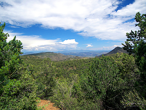
Grand-ville Enchantment by PrestonSands   Overview OverviewThe Pinal Trail #713 is a connector trail that runs between Granville Campground and the Frye Trail #12 (part of the Grand Enchantment Trail) in the mountains north of Clifton, Arizona. Although lightly traveled, this trail is in excellent shape and is easy to follow, with a definite footpath and plenty of blazes marking the route. Highlights of this hike include far-reaching views into New Mexico, colorful bedrock in various hues of red, white, and grey, and plentiful greenery. History The trail begins at the Granville Campground, which was the site of an early logging camp and summer retreat known as Granville. The logging operation here supplied the copper mines of the Clifton and Metcalf areas with lumber. The only structures remaining in Granville are the more recently built forest service cabins.
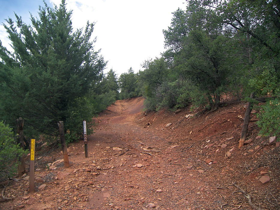
The hike begins near several cabins on the east side of the Granville Campground loop road. At the highest part of the loop road, there is a side road heading uphill to the north, away from the campground and cabins, that is identified by a vertical brown signpost with the word trail. This side road is the Granville Trail #572. Follow the Granville Trail north for a few hundred feet until you come to an opening in a barbed-wire fence, where there is a second vertical brown signpost with the word trail. There is a wooden sign nailed to a tree on your right identifying this as the junction with the Pinal Trail. The Pinal Trail begins by climbing the embankment to your right, then doubling back to the south to follow a barbed wire fence for a while. A little ways on, the trail bends left (southeast) to begin a steady climb up a mountainside densely wooded in pinyon, scrub oak, and juniper. The trail gradually curves east, then north to traverse a side canyon of Chase Creek. On the east side of this canyon, there is a sizable outcrop of white conglomerate rock on the south side of the trail, where one can enjoy a fine view of the surrounding peaks and the Morenci mining operation. Continuing, the trail reaches its high point while passing through a broad saddle shaded by ponderosa pines and Gambel oaks. The Pinal Trail turns north to leave the saddle and begins a steady descent into upper Cave Creek canyon. Pines give way to pinyon-oak woodland, as the trail negotiates two small ridges. Openings in the thick vegetation allow for distant views of the Gila Wilderness and the Blue River area. At 1.8 miles, the trail crosses a small bench where a clearing in the junipers reveals a decent campsite. The Pinal Trail then drops off the east side of the bench to meet the Frye Trail #12 at mile 2, on a slope above upper Fry Canyon. The Frye Trail is not signed at the junction, but the Pinal Trail is. From this point, one can continue north or south along the Frye Trail (Grand Enchantment Trail), or complete a loop hike by heading north and taking the Granville Trail #572 back to Granville Campground. Otherwise, return the way you came. Check out the Official Route and Triplogs. Leave No Trace and +Add a Triplog after your hike to support this local community. | ||||||||||||||||||||||||||||||||||||||||||||||||||||||||||||||||||||||||||||||||||


